You are here: Home > Network List > TA - USArray Transportable Network (new EarthScope stations) Stations List
> Station 249A Camden, AL, USA > Earthquake Result Viewer
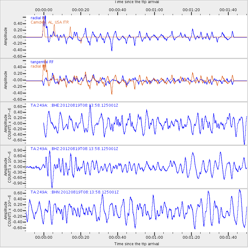
249A Camden, AL, USA - Earthquake Result Viewer
*The percent match for this event was below the threshold and hence no stack was calculated.
| Earthquake location: |
Off Coast Of Washington |
| Earthquake latitude/longitude: |
47.8/-128.6 |
| Earthquake time(UTC): |
2012/08/19 (232) 08:07:35 GMT |
| Earthquake Depth: |
10 km |
| Earthquake Magnitude: |
5.6 MW, 5.3 MS, 5.2 MB, 5.5 MW |
| Earthquake Catalog/Contributor: |
WHDF/NEIC |
|
| Network: |
TA USArray Transportable Network (new EarthScope stations) |
| Station: |
249A Camden, AL, USA |
| Lat/Lon: |
31.98 N/87.12 W |
| Elevation: |
66 m |
|
| Distance: |
35.1 deg |
| Az: |
101.511 deg |
| Baz: |
308.968 deg |
| Ray Param: |
$rayparam |
*The percent match for this event was below the threshold and hence was not used in the summary stack. |
|
| Radial Match: |
52.192627 % |
| Radial Bump: |
335 |
| Transverse Match: |
47.154106 % |
| Transverse Bump: |
352 |
| SOD ConfigId: |
469095 |
| Insert Time: |
2013-02-22 07:33:53.300 +0000 |
| GWidth: |
2.5 |
| Max Bumps: |
400 |
| Tol: |
0.001 |
|
Signal To Noise
| Channel | StoN | STA | LTA |
| TA:249A: :BHZ:20120819T08:13:58.125001Z | 4.2704268 | 5.2878073E-7 | 1.2382387E-7 |
| TA:249A: :BHN:20120819T08:13:58.125001Z | 1.3880621 | 2.6006987E-7 | 1.8736183E-7 |
| TA:249A: :BHE:20120819T08:13:58.125001Z | 1.0772815 | 2.3231706E-7 | 2.1565123E-7 |
| Arrivals |
| Ps | |
| PpPs | |
| PsPs/PpSs | |


