You are here: Home > Network List > TA - USArray Transportable Network (new EarthScope stations) Stations List
> Station 554A Perry, FL, USA > Earthquake Result Viewer
554A Perry, FL, USA - Earthquake Result Viewer
| Earthquake location: |
Off Coast Of Washington |
| Earthquake latitude/longitude: |
47.8/-128.6 |
| Earthquake time(UTC): |
2012/08/19 (232) 08:07:35 GMT |
| Earthquake Depth: |
10 km |
| Earthquake Magnitude: |
5.6 MW, 5.3 MS, 5.2 MB, 5.5 MW |
| Earthquake Catalog/Contributor: |
WHDF/NEIC |
|
| Network: |
TA USArray Transportable Network (new EarthScope stations) |
| Station: |
554A Perry, FL, USA |
| Lat/Lon: |
30.08 N/83.68 W |
| Elevation: |
12 m |
|
| Distance: |
38.6 deg |
| Az: |
100.797 deg |
| Baz: |
310.161 deg |
| Ray Param: |
0.075496085 |
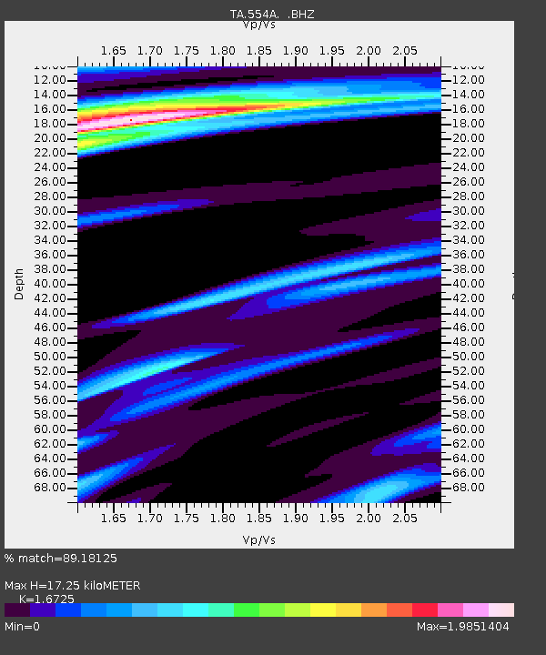
| Estimated Moho Depth: |
17.25 km |
| Estimated Crust Vp/Vs: |
1.67 |
| Assumed Crust Vp: |
6.565 km/s |
| Estimated Crust Vs: |
3.925 km/s |
| Estimated Crust Poisson's Ratio: |
0.22 |
|
| Radial Match: |
89.18125 % |
| Radial Bump: |
283 |
| Transverse Match: |
48.935623 % |
| Transverse Bump: |
400 |
| SOD ConfigId: |
469095 |
| Insert Time: |
2013-02-22 07:35:23.338 +0000 |
| GWidth: |
2.5 |
| Max Bumps: |
400 |
| Tol: |
0.001 |
|

Signal To Noise
| Channel | StoN | STA | LTA |
| TA:554A: :BHZ:20120819T08:14:27.674989Z | 2.5551171 | 4.1770997E-7 | 1.6347977E-7 |
| TA:554A: :BHN:20120819T08:14:27.674989Z | 0.9634519 | 1.1919024E-7 | 1.2371167E-7 |
| TA:554A: :BHE:20120819T08:14:27.674989Z | 0.8637207 | 1.1084381E-7 | 1.2833293E-7 |
| Arrivals |
| Ps | 1.9 SECOND |
| PpPs | 6.5 SECOND |
| PsPs/PpSs | 8.4 SECOND |


