You are here: Home > Network List > TA - USArray Transportable Network (new EarthScope stations) Stations List
> Station 555A McAlpin, FL, USA > Earthquake Result Viewer
555A McAlpin, FL, USA - Earthquake Result Viewer
| Earthquake location: |
Off Coast Of Washington |
| Earthquake latitude/longitude: |
47.8/-128.6 |
| Earthquake time(UTC): |
2012/08/19 (232) 08:07:35 GMT |
| Earthquake Depth: |
10 km |
| Earthquake Magnitude: |
5.6 MW, 5.3 MS, 5.2 MB, 5.5 MW |
| Earthquake Catalog/Contributor: |
WHDF/NEIC |
|
| Network: |
TA USArray Transportable Network (new EarthScope stations) |
| Station: |
555A McAlpin, FL, USA |
| Lat/Lon: |
30.12 N/82.97 W |
| Elevation: |
29 m |
|
| Distance: |
39.0 deg |
| Az: |
100.113 deg |
| Baz: |
309.986 deg |
| Ray Param: |
0.075235195 |
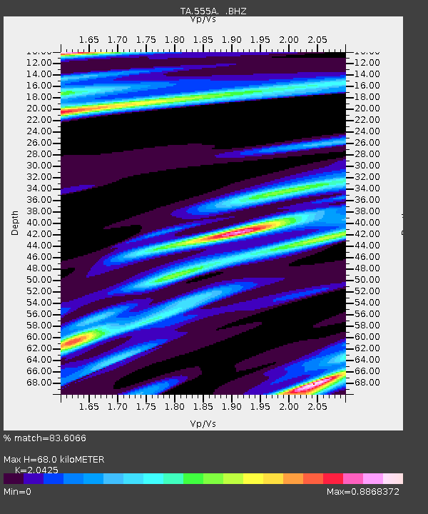
| Estimated Moho Depth: |
68.0 km |
| Estimated Crust Vp/Vs: |
2.04 |
| Assumed Crust Vp: |
6.565 km/s |
| Estimated Crust Vs: |
3.214 km/s |
| Estimated Crust Poisson's Ratio: |
0.34 |
|
| Radial Match: |
83.6066 % |
| Radial Bump: |
282 |
| Transverse Match: |
53.49329 % |
| Transverse Bump: |
400 |
| SOD ConfigId: |
469095 |
| Insert Time: |
2013-02-22 07:35:25.780 +0000 |
| GWidth: |
2.5 |
| Max Bumps: |
400 |
| Tol: |
0.001 |
|
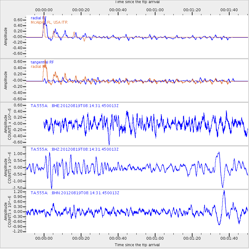
Signal To Noise
| Channel | StoN | STA | LTA |
| TA:555A: :BHZ:20120819T08:14:31.450013Z | 4.176271 | 6.8625553E-7 | 1.6432254E-7 |
| TA:555A: :BHN:20120819T08:14:31.450013Z | 1.5150862 | 1.5198191E-7 | 1.00312384E-7 |
| TA:555A: :BHE:20120819T08:14:31.450013Z | 1.160273 | 1.5306492E-7 | 1.3192147E-7 |
| Arrivals |
| Ps | 12 SECOND |
| PpPs | 30 SECOND |
| PsPs/PpSs | 41 SECOND |


