You are here: Home > Network List > TA - USArray Transportable Network (new EarthScope stations) Stations List
> Station 352A Blakely, GA, USA > Earthquake Result Viewer
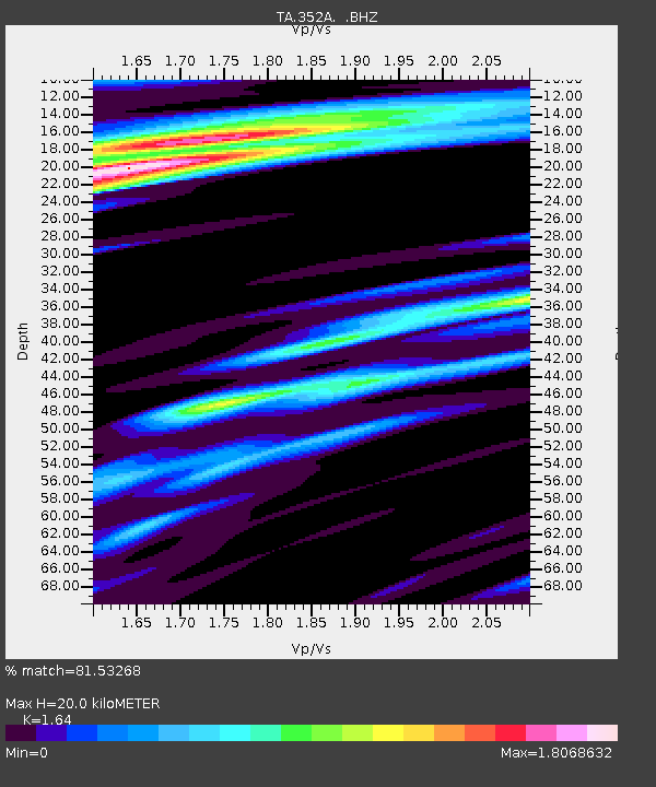
352A Blakely, GA, USA - Earthquake Result Viewer
| Earthquake location: |
Off Coast Of Washington |
| Earthquake latitude/longitude: |
47.8/-128.6 |
| Earthquake time(UTC): |
2012/08/19 (232) 08:07:35 GMT |
| Earthquake Depth: |
10 km |
| Earthquake Magnitude: |
5.6 MW, 5.3 MS, 5.2 MB, 5.5 MW |
| Earthquake Catalog/Contributor: |
WHDF/NEIC |
|
| Network: |
TA USArray Transportable Network (new EarthScope stations) |
| Station: |
352A Blakely, GA, USA |
| Lat/Lon: |
31.48 N/84.93 W |
| Elevation: |
101 m |
|
| Distance: |
36.8 deg |
| Az: |
100.16 deg |
| Baz: |
309.024 deg |
| Ray Param: |
0.07646128 |
| Estimated Moho Depth: |
20.0 km |
| Estimated Crust Vp/Vs: |
1.64 |
| Assumed Crust Vp: |
6.347 km/s |
| Estimated Crust Vs: |
3.87 km/s |
| Estimated Crust Poisson's Ratio: |
0.20 |
|
| Radial Match: |
81.53268 % |
| Radial Bump: |
337 |
| Transverse Match: |
42.61825 % |
| Transverse Bump: |
396 |
| SOD ConfigId: |
469095 |
| Insert Time: |
2013-02-22 07:35:49.046 +0000 |
| GWidth: |
2.5 |
| Max Bumps: |
400 |
| Tol: |
0.001 |
|

Signal To Noise
| Channel | StoN | STA | LTA |
| TA:352A: :BHZ:20120819T08:14:13.200013Z | 5.1366053 | 5.499441E-7 | 1.0706373E-7 |
| TA:352A: :BHN:20120819T08:14:13.200013Z | 1.2513382 | 2.270048E-7 | 1.8140962E-7 |
| TA:352A: :BHE:20120819T08:14:13.200013Z | 1.1439378 | 2.2809972E-7 | 1.993987E-7 |
| Arrivals |
| Ps | 2.2 SECOND |
| PpPs | 7.7 SECOND |
| PsPs/PpSs | 9.9 SECOND |


