You are here: Home > Network List > YB13 - Continental Dynamics/Cent. Anatolian Tectonics:Surface to Mantle Dynamics During Stations List
> Station AT20 Kirkpinar,Kersehir,Turkey > Earthquake Result Viewer
AT20 Kirkpinar,Kersehir,Turkey - Earthquake Result Viewer
| Earthquake location: |
Northern Alaska |
| Earthquake latitude/longitude: |
67.9/-162.4 |
| Earthquake time(UTC): |
2014/06/07 (158) 04:43:34 GMT |
| Earthquake Depth: |
14 km |
| Earthquake Magnitude: |
6.0 MI |
| Earthquake Catalog/Contributor: |
NEIC PDE/NEIC ALERT |
|
| Network: |
YB Continental Dynamics/Cent. Anatolian Tectonics:Surface to Mantle Dynamics During |
| Station: |
AT20 Kirkpinar,Kersehir,Turkey |
| Lat/Lon: |
39.36 N/34.16 E |
| Elevation: |
1235 m |
|
| Distance: |
72.3 deg |
| Az: |
346.614 deg |
| Baz: |
6.493 deg |
| Ray Param: |
0.053712375 |
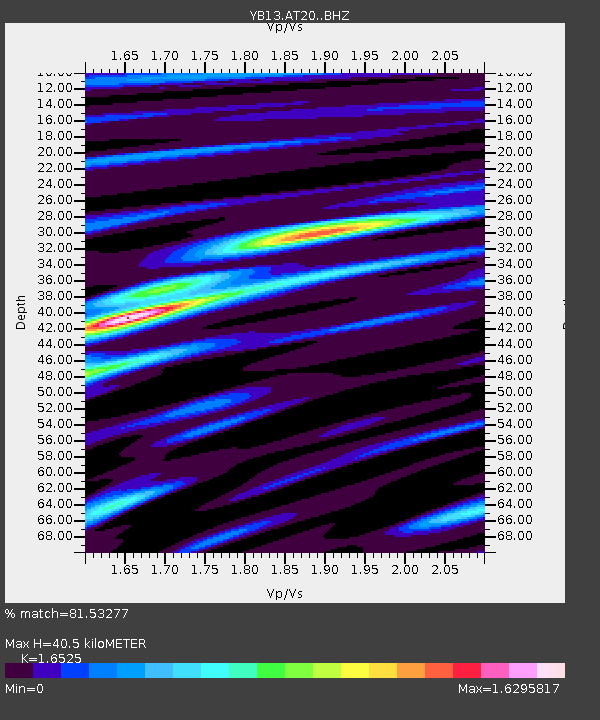
| Estimated Moho Depth: |
40.5 km |
| Estimated Crust Vp/Vs: |
1.65 |
| Assumed Crust Vp: |
6.35 km/s |
| Estimated Crust Vs: |
3.843 km/s |
| Estimated Crust Poisson's Ratio: |
0.21 |
|
| Radial Match: |
81.53277 % |
| Radial Bump: |
320 |
| Transverse Match: |
51.82878 % |
| Transverse Bump: |
400 |
| SOD ConfigId: |
3390531 |
| Insert Time: |
2019-04-12 04:54:13.556 +0000 |
| GWidth: |
2.5 |
| Max Bumps: |
400 |
| Tol: |
0.001 |
|

Signal To Noise
| Channel | StoN | STA | LTA |
| YB:AT20: :BHZ:20140607T04:54:28.900024Z | 5.51571 | 4.556496E-7 | 8.260942E-8 |
| YB:AT20: :BHN:20140607T04:54:28.900024Z | 2.4762397 | 1.9501115E-7 | 7.875294E-8 |
| YB:AT20: :BHE:20140607T04:54:28.900024Z | 0.7519512 | 5.442602E-8 | 7.237972E-8 |
| Arrivals |
| Ps | 4.3 SECOND |
| PpPs | 16 SECOND |
| PsPs/PpSs | 21 SECOND |


