You are here: Home > Network List > TA - USArray Transportable Network (new EarthScope stations) Stations List
> Station U51A La Follette, TN, USA > Earthquake Result Viewer
U51A La Follette, TN, USA - Earthquake Result Viewer
*The percent match for this event was below the threshold and hence no stack was calculated.
| Earthquake location: |
Off Coast Of Washington |
| Earthquake latitude/longitude: |
47.8/-128.6 |
| Earthquake time(UTC): |
2012/08/19 (232) 08:07:35 GMT |
| Earthquake Depth: |
10 km |
| Earthquake Magnitude: |
5.6 MW, 5.3 MS, 5.2 MB, 5.5 MW |
| Earthquake Catalog/Contributor: |
WHDF/NEIC |
|
| Network: |
TA USArray Transportable Network (new EarthScope stations) |
| Station: |
U51A La Follette, TN, USA |
| Lat/Lon: |
36.38 N/84.02 W |
| Elevation: |
472 m |
|
| Distance: |
34.6 deg |
| Az: |
92.634 deg |
| Baz: |
303.414 deg |
| Ray Param: |
$rayparam |
*The percent match for this event was below the threshold and hence was not used in the summary stack. |
|
| Radial Match: |
59.624622 % |
| Radial Bump: |
400 |
| Transverse Match: |
52.179314 % |
| Transverse Bump: |
400 |
| SOD ConfigId: |
469095 |
| Insert Time: |
2013-02-22 07:39:30.724 +0000 |
| GWidth: |
2.5 |
| Max Bumps: |
400 |
| Tol: |
0.001 |
|
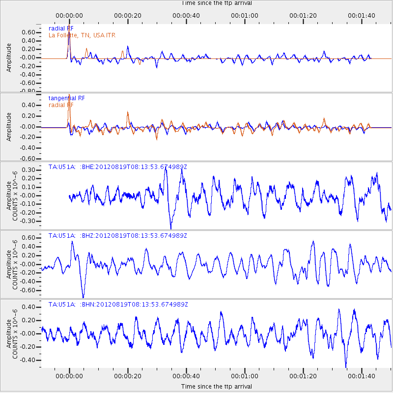
Signal To Noise
| Channel | StoN | STA | LTA |
| TA:U51A: :BHZ:20120819T08:13:53.674989Z | 3.9328234 | 3.307444E-7 | 8.409846E-8 |
| TA:U51A: :BHN:20120819T08:13:53.674989Z | 1.3248729 | 8.033188E-8 | 6.063365E-8 |
| TA:U51A: :BHE:20120819T08:13:53.674989Z | 3.4675071 | 1.7708712E-7 | 5.107044E-8 |
| Arrivals |
| Ps | |
| PpPs | |
| PsPs/PpSs | |


