You are here: Home > Network List > TA - USArray Transportable Network (new EarthScope stations) Stations List
> Station P48A Milroy, IN, USA > Earthquake Result Viewer
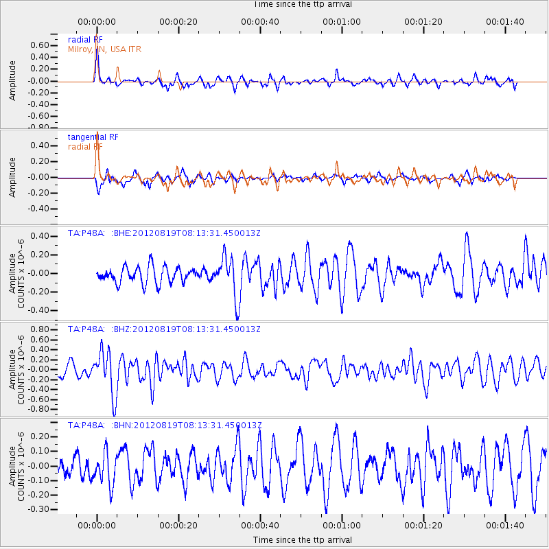
P48A Milroy, IN, USA - Earthquake Result Viewer
*The percent match for this event was below the threshold and hence no stack was calculated.
| Earthquake location: |
Off Coast Of Washington |
| Earthquake latitude/longitude: |
47.8/-128.6 |
| Earthquake time(UTC): |
2012/08/19 (232) 08:07:35 GMT |
| Earthquake Depth: |
10 km |
| Earthquake Magnitude: |
5.6 MW, 5.3 MS, 5.2 MB, 5.5 MW |
| Earthquake Catalog/Contributor: |
WHDF/NEIC |
|
| Network: |
TA USArray Transportable Network (new EarthScope stations) |
| Station: |
P48A Milroy, IN, USA |
| Lat/Lon: |
39.46 N/85.43 W |
| Elevation: |
300 m |
|
| Distance: |
32.0 deg |
| Az: |
88.909 deg |
| Baz: |
299.436 deg |
| Ray Param: |
$rayparam |
*The percent match for this event was below the threshold and hence was not used in the summary stack. |
|
| Radial Match: |
67.50802 % |
| Radial Bump: |
356 |
| Transverse Match: |
47.46449 % |
| Transverse Bump: |
385 |
| SOD ConfigId: |
469095 |
| Insert Time: |
2013-02-22 07:40:55.537 +0000 |
| GWidth: |
2.5 |
| Max Bumps: |
400 |
| Tol: |
0.001 |
|
Signal To Noise
| Channel | StoN | STA | LTA |
| TA:P48A: :BHZ:20120819T08:13:31.450013Z | 2.3510473 | 4.483463E-7 | 1.9070067E-7 |
| TA:P48A: :BHN:20120819T08:13:31.450013Z | 0.72957575 | 1.1403988E-7 | 1.5630985E-7 |
| TA:P48A: :BHE:20120819T08:13:31.450013Z | 2.6604474 | 2.2666237E-7 | 8.5197094E-8 |
| Arrivals |
| Ps | |
| PpPs | |
| PsPs/PpSs | |


