You are here: Home > Network List > G - GEOSCOPE Stations List
> Station TAM Tamanrasset, Algeria > Earthquake Result Viewer
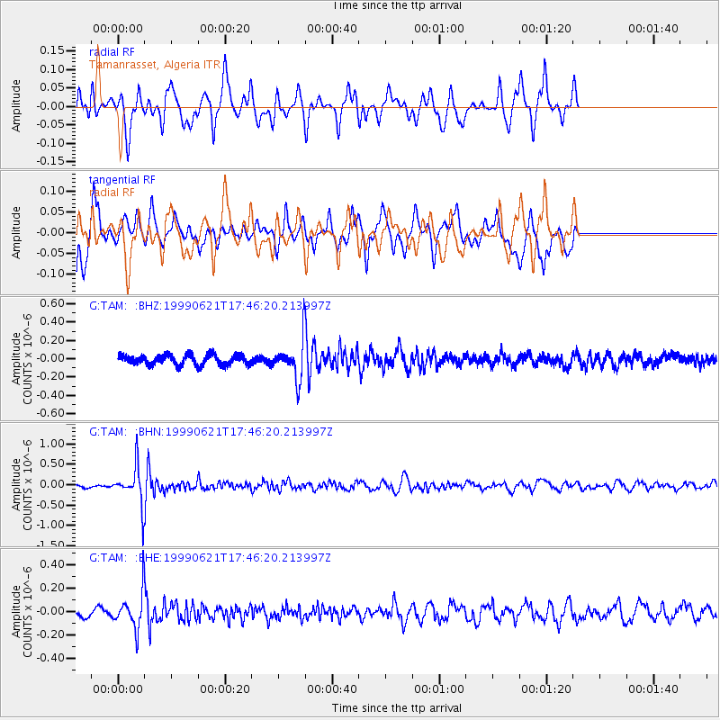
TAM Tamanrasset, Algeria - Earthquake Result Viewer
*The percent match for this event was below the threshold and hence no stack was calculated.
| Earthquake location: |
Hindu Kush Region, Afghanistan |
| Earthquake latitude/longitude: |
36.4/70.7 |
| Earthquake time(UTC): |
1999/06/21 (172) 17:37:27 GMT |
| Earthquake Depth: |
230 km |
| Earthquake Magnitude: |
5.6 MW, 5.4 MB, 5.5 MW |
| Earthquake Catalog/Contributor: |
WHDF/NEIC |
|
| Network: |
G GEOSCOPE |
| Station: |
TAM Tamanrasset, Algeria |
| Lat/Lon: |
22.79 N/5.53 E |
| Elevation: |
1377 m |
|
| Distance: |
57.3 deg |
| Az: |
275.59 deg |
| Baz: |
60.484 deg |
| Ray Param: |
$rayparam |
*The percent match for this event was below the threshold and hence was not used in the summary stack. |
|
| Radial Match: |
79.94179 % |
| Radial Bump: |
400 |
| Transverse Match: |
55.469208 % |
| Transverse Bump: |
400 |
| SOD ConfigId: |
4480 |
| Insert Time: |
2010-02-27 00:36:50.594 +0000 |
| GWidth: |
2.5 |
| Max Bumps: |
400 |
| Tol: |
0.001 |
|
Signal To Noise
| Channel | StoN | STA | LTA |
| G:TAM: :BHN:19990621T17:46:20.213997Z | 8.858387 | 4.60413E-7 | 5.197481E-8 |
| G:TAM: :BHE:19990621T17:46:20.213997Z | 3.399793 | 1.5329469E-7 | 4.508942E-8 |
| G:TAM: :BHZ:19990621T17:46:20.213997Z | 3.5279775 | 2.0029664E-7 | 5.6773782E-8 |
| Arrivals |
| Ps | |
| PpPs | |
| PsPs/PpSs | |


