You are here: Home > Network List > AK - Alaska Regional Network Stations List
> Station MDM Murphy Dome > Earthquake Result Viewer
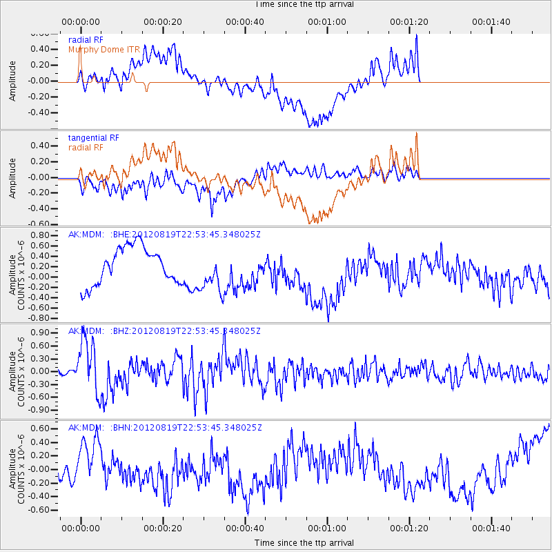
MDM Murphy Dome - Earthquake Result Viewer
*The percent match for this event was below the threshold and hence no stack was calculated.
| Earthquake location: |
Near N Coast Of New Guinea, P.N.G. |
| Earthquake latitude/longitude: |
-4.8/144.6 |
| Earthquake time(UTC): |
2012/08/19 (232) 22:41:49 GMT |
| Earthquake Depth: |
73 km |
| Earthquake Magnitude: |
6.0 MB, 6.2 MW, 6.3 MW |
| Earthquake Catalog/Contributor: |
WHDF/NEIC |
|
| Network: |
AK Alaska Regional Network |
| Station: |
MDM Murphy Dome |
| Lat/Lon: |
64.96 N/148.23 W |
| Elevation: |
634 m |
|
| Distance: |
84.9 deg |
| Az: |
23.2 deg |
| Baz: |
247.286 deg |
| Ray Param: |
$rayparam |
*The percent match for this event was below the threshold and hence was not used in the summary stack. |
|
| Radial Match: |
45.64998 % |
| Radial Bump: |
400 |
| Transverse Match: |
43.90218 % |
| Transverse Bump: |
400 |
| SOD ConfigId: |
469095 |
| Insert Time: |
2013-02-22 07:42:46.904 +0000 |
| GWidth: |
2.5 |
| Max Bumps: |
400 |
| Tol: |
0.001 |
|
Signal To Noise
| Channel | StoN | STA | LTA |
| AK:MDM: :BHZ:20120819T22:53:45.348025Z | 8.092453 | 6.4233666E-7 | 7.937478E-8 |
| AK:MDM: :BHN:20120819T22:53:45.348025Z | 0.98618495 | 2.6701383E-7 | 2.7075433E-7 |
| AK:MDM: :BHE:20120819T22:53:45.348025Z | 1.1408755 | 4.0478838E-7 | 3.5480505E-7 |
| Arrivals |
| Ps | |
| PpPs | |
| PsPs/PpSs | |


