You are here: Home > Network List > G - GEOSCOPE Stations List
> Station TAM Tamanrasset, Algeria > Earthquake Result Viewer
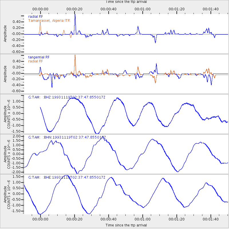
TAM Tamanrasset, Algeria - Earthquake Result Viewer
*The percent match for this event was below the threshold and hence no stack was calculated.
| Earthquake location: |
Near Coast Of Chiapas, Mexico |
| Earthquake latitude/longitude: |
14.8/-94.0 |
| Earthquake time(UTC): |
1993/11/19 (323) 02:25:08 GMT |
| Earthquake Depth: |
25 km |
| Earthquake Magnitude: |
5.5 MB |
| Earthquake Catalog/Contributor: |
WHDF/NEIC |
|
| Network: |
G GEOSCOPE |
| Station: |
TAM Tamanrasset, Algeria |
| Lat/Lon: |
22.79 N/5.53 E |
| Elevation: |
1377 m |
|
| Distance: |
92.8 deg |
| Az: |
65.685 deg |
| Baz: |
287.236 deg |
| Ray Param: |
$rayparam |
*The percent match for this event was below the threshold and hence was not used in the summary stack. |
|
| Radial Match: |
79.44275 % |
| Radial Bump: |
273 |
| Transverse Match: |
73.915695 % |
| Transverse Bump: |
400 |
| SOD ConfigId: |
4480 |
| Insert Time: |
2010-02-27 00:36:52.423 +0000 |
| GWidth: |
2.5 |
| Max Bumps: |
400 |
| Tol: |
0.001 |
|
Signal To Noise
| Channel | StoN | STA | LTA |
| G:TAM: :BHN:19931119T02:37:47.855017Z | 0.59174544 | 5.7229727E-7 | 9.671343E-7 |
| G:TAM: :BHE:19931119T02:37:47.855017Z | 1.9768022 | 1.721378E-6 | 8.7078917E-7 |
| G:TAM: :BHZ:19931119T02:37:47.855017Z | 1.4398925 | 1.4468758E-6 | 1.0048499E-6 |
| Arrivals |
| Ps | |
| PpPs | |
| PsPs/PpSs | |


