You are here: Home > Network List > G - GEOSCOPE Stations List
> Station INU Inuyama, Japan > Earthquake Result Viewer
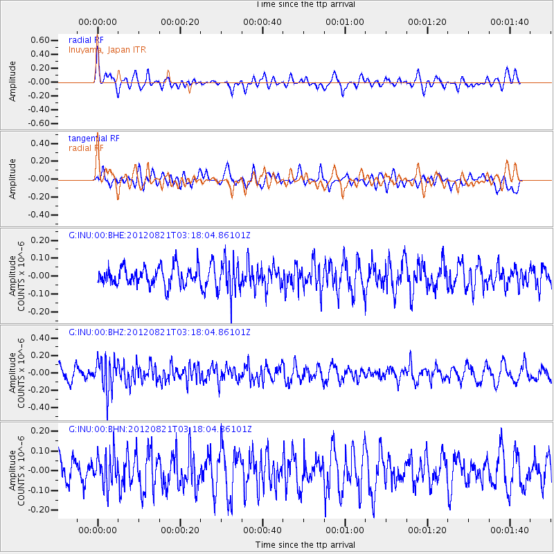
INU Inuyama, Japan - Earthquake Result Viewer
*The percent match for this event was below the threshold and hence no stack was calculated.
| Earthquake location: |
Southern Sumatra, Indonesia |
| Earthquake latitude/longitude: |
-4.7/103.0 |
| Earthquake time(UTC): |
2012/08/21 (234) 03:09:39 GMT |
| Earthquake Depth: |
66 km |
| Earthquake Magnitude: |
5.5 MB, 5.2 MW |
| Earthquake Catalog/Contributor: |
WHDF/NEIC |
|
| Network: |
G GEOSCOPE |
| Station: |
INU Inuyama, Japan |
| Lat/Lon: |
35.35 N/137.03 E |
| Elevation: |
132 m |
|
| Distance: |
51.1 deg |
| Az: |
35.999 deg |
| Baz: |
225.773 deg |
| Ray Param: |
$rayparam |
*The percent match for this event was below the threshold and hence was not used in the summary stack. |
|
| Radial Match: |
43.416134 % |
| Radial Bump: |
400 |
| Transverse Match: |
50.11051 % |
| Transverse Bump: |
400 |
| SOD ConfigId: |
469095 |
| Insert Time: |
2013-02-22 07:51:30.542 +0000 |
| GWidth: |
2.5 |
| Max Bumps: |
400 |
| Tol: |
0.001 |
|
Signal To Noise
| Channel | StoN | STA | LTA |
| G:INU:00:BHZ:20120821T03:18:04.86101Z | 2.4345548 | 1.8626055E-7 | 7.650703E-8 |
| G:INU:00:BHN:20120821T03:18:04.86101Z | 1.0281975 | 8.2328754E-8 | 8.0070954E-8 |
| G:INU:00:BHE:20120821T03:18:04.86101Z | 1.8600024 | 9.3869595E-8 | 5.046746E-8 |
| Arrivals |
| Ps | |
| PpPs | |
| PsPs/PpSs | |


