You are here: Home > Network List > KN - Kyrgyz Seismic Telemetry Network Stations List
> Station TKM2 - > Earthquake Result Viewer
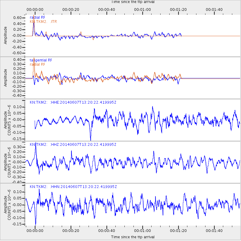
TKM2 - - Earthquake Result Viewer
*The percent match for this event was below the threshold and hence no stack was calculated.
| Earthquake location: |
Kuril Islands |
| Earthquake latitude/longitude: |
50.7/157.1 |
| Earthquake time(UTC): |
2014/06/07 (158) 13:11:37 GMT |
| Earthquake Depth: |
56 km |
| Earthquake Magnitude: |
5.6 M |
| Earthquake Catalog/Contributor: |
NEIC PDE/NEIC ALERT |
|
| Network: |
KN Kyrgyz Seismic Telemetry Network |
| Station: |
TKM2 - |
| Lat/Lon: |
42.92 N/75.60 E |
| Elevation: |
2020 m |
|
| Distance: |
53.7 deg |
| Az: |
295.578 deg |
| Baz: |
51.326 deg |
| Ray Param: |
$rayparam |
*The percent match for this event was below the threshold and hence was not used in the summary stack. |
|
| Radial Match: |
69.914505 % |
| Radial Bump: |
400 |
| Transverse Match: |
57.095135 % |
| Transverse Bump: |
400 |
| SOD ConfigId: |
3390531 |
| Insert Time: |
2019-04-12 05:05:11.211 +0000 |
| GWidth: |
2.5 |
| Max Bumps: |
400 |
| Tol: |
0.001 |
|
Signal To Noise
| Channel | StoN | STA | LTA |
| KN:TKM2: :HHZ:20140607T13:20:22.419995Z | 5.426939 | 1.4167257E-7 | 2.6105429E-8 |
| KN:TKM2: :HHN:20140607T13:20:22.419995Z | 2.4016151 | 5.7696443E-8 | 2.4024017E-8 |
| KN:TKM2: :HHE:20140607T13:20:22.419995Z | 3.1315067 | 5.6867528E-8 | 1.8159799E-8 |
| Arrivals |
| Ps | |
| PpPs | |
| PsPs/PpSs | |


