You are here: Home > Network List > CI - Caltech Regional Seismic Network Stations List
> Station MPP McPhearson Peak > Earthquake Result Viewer
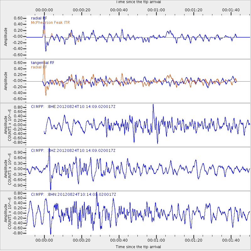
MPP McPhearson Peak - Earthquake Result Viewer
*The percent match for this event was below the threshold and hence no stack was calculated.
| Earthquake location: |
South Of Kermadec Islands |
| Earthquake latitude/longitude: |
-33.4/-179.5 |
| Earthquake time(UTC): |
2012/08/24 (237) 10:01:53 GMT |
| Earthquake Depth: |
38 km |
| Earthquake Magnitude: |
5.6 MW, 5.1 MS, 5.2 MB, 5.8 MW |
| Earthquake Catalog/Contributor: |
WHDF/NEIC |
|
| Network: |
CI Caltech Regional Seismic Network |
| Station: |
MPP McPhearson Peak |
| Lat/Lon: |
34.89 N/119.81 W |
| Elevation: |
1739 m |
|
| Distance: |
88.0 deg |
| Az: |
45.261 deg |
| Baz: |
226.265 deg |
| Ray Param: |
$rayparam |
*The percent match for this event was below the threshold and hence was not used in the summary stack. |
|
| Radial Match: |
61.638046 % |
| Radial Bump: |
400 |
| Transverse Match: |
39.98581 % |
| Transverse Bump: |
400 |
| SOD ConfigId: |
469095 |
| Insert Time: |
2013-02-22 08:01:32.006 +0000 |
| GWidth: |
2.5 |
| Max Bumps: |
400 |
| Tol: |
0.001 |
|
Signal To Noise
| Channel | StoN | STA | LTA |
| CI:MPP: :BHZ:20120824T10:14:09.020017Z | 3.2341847 | 4.864331E-7 | 1.5040362E-7 |
| CI:MPP: :BHN:20120824T10:14:09.020017Z | 1.3030784 | 3.8995233E-7 | 2.992547E-7 |
| CI:MPP: :BHE:20120824T10:14:09.020017Z | 0.9811929 | 2.012389E-7 | 2.0509617E-7 |
| Arrivals |
| Ps | |
| PpPs | |
| PsPs/PpSs | |


