You are here: Home > Network List > G - GEOSCOPE Stations List
> Station TAOE Taiohae, Marquises islands > Earthquake Result Viewer
TAOE Taiohae, Marquises islands - Earthquake Result Viewer
| Earthquake location: |
Samoa Islands Region |
| Earthquake latitude/longitude: |
-15.5/-172.1 |
| Earthquake time(UTC): |
2009/09/29 (272) 17:48:10 GMT |
| Earthquake Depth: |
18 km |
| Earthquake Magnitude: |
7.1 MB, 8.1 MS, 8.1 MW, 8.0 MW |
| Earthquake Catalog/Contributor: |
WHDF/NEIC |
|
| Network: |
G GEOSCOPE |
| Station: |
TAOE Taiohae, Marquises islands |
| Lat/Lon: |
8.85 S/140.15 W |
| Elevation: |
800 m |
|
| Distance: |
31.9 deg |
| Az: |
81.827 deg |
| Baz: |
254.952 deg |
| Ray Param: |
0.078869246 |
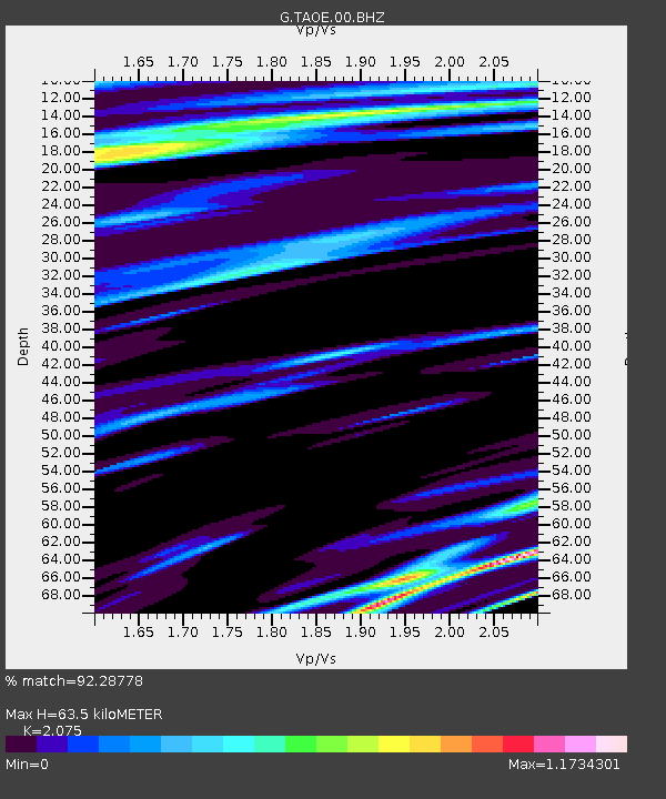
| Estimated Moho Depth: |
63.5 km |
| Estimated Crust Vp/Vs: |
2.08 |
| Assumed Crust Vp: |
4.24 km/s |
| Estimated Crust Vs: |
2.043 km/s |
| Estimated Crust Poisson's Ratio: |
0.35 |
|
| Radial Match: |
92.28778 % |
| Radial Bump: |
174 |
| Transverse Match: |
91.29119 % |
| Transverse Bump: |
400 |
| SOD ConfigId: |
2622 |
| Insert Time: |
2010-02-27 00:37:05.684 +0000 |
| GWidth: |
2.5 |
| Max Bumps: |
400 |
| Tol: |
0.001 |
|
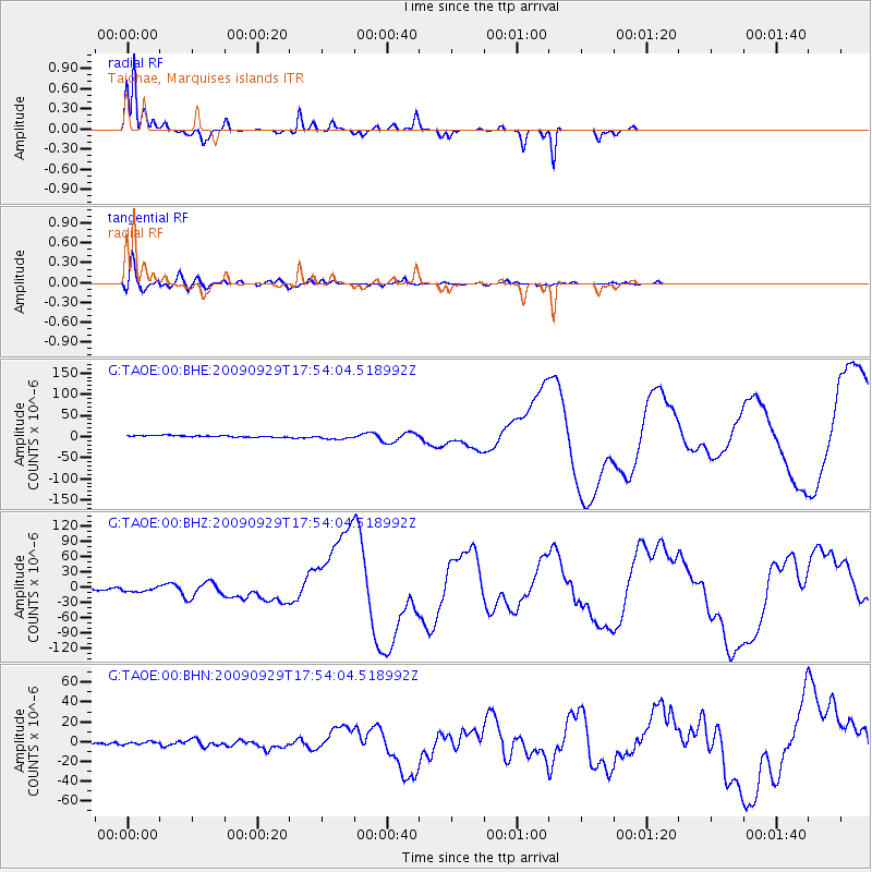
Signal To Noise
| Channel | StoN | STA | LTA |
| G:TAOE:00:BHZ:20090929T17:54:04.518992Z | 2.3149214 | 4.673613E-6 | 2.0189077E-6 |
| G:TAOE:00:BHN:20090929T17:54:04.518992Z | 0.8267555 | 1.4306381E-6 | 1.7304246E-6 |
| G:TAOE:00:BHE:20090929T17:54:04.518992Z | 3.0950463 | 5.729899E-6 | 1.851313E-6 |
| Arrivals |
| Ps | 17 SECOND |
| PpPs | 45 SECOND |
| PsPs/PpSs | 61 SECOND |


