You are here: Home > Network List > CI - Caltech Regional Seismic Network Stations List
> Station MUR Murrieta > Earthquake Result Viewer
MUR Murrieta - Earthquake Result Viewer
*The percent match for this event was below the threshold and hence no stack was calculated.
| Earthquake location: |
South Of Kermadec Islands |
| Earthquake latitude/longitude: |
-33.4/-179.5 |
| Earthquake time(UTC): |
2012/08/24 (237) 10:01:53 GMT |
| Earthquake Depth: |
38 km |
| Earthquake Magnitude: |
5.6 MW, 5.1 MS, 5.2 MB, 5.8 MW |
| Earthquake Catalog/Contributor: |
WHDF/NEIC |
|
| Network: |
CI Caltech Regional Seismic Network |
| Station: |
MUR Murrieta |
| Lat/Lon: |
33.60 N/117.20 W |
| Elevation: |
562 m |
|
| Distance: |
88.7 deg |
| Az: |
47.681 deg |
| Baz: |
227.8 deg |
| Ray Param: |
$rayparam |
*The percent match for this event was below the threshold and hence was not used in the summary stack. |
|
| Radial Match: |
69.4998 % |
| Radial Bump: |
373 |
| Transverse Match: |
74.33084 % |
| Transverse Bump: |
400 |
| SOD ConfigId: |
469095 |
| Insert Time: |
2013-02-22 08:02:41.342 +0000 |
| GWidth: |
2.5 |
| Max Bumps: |
400 |
| Tol: |
0.001 |
|
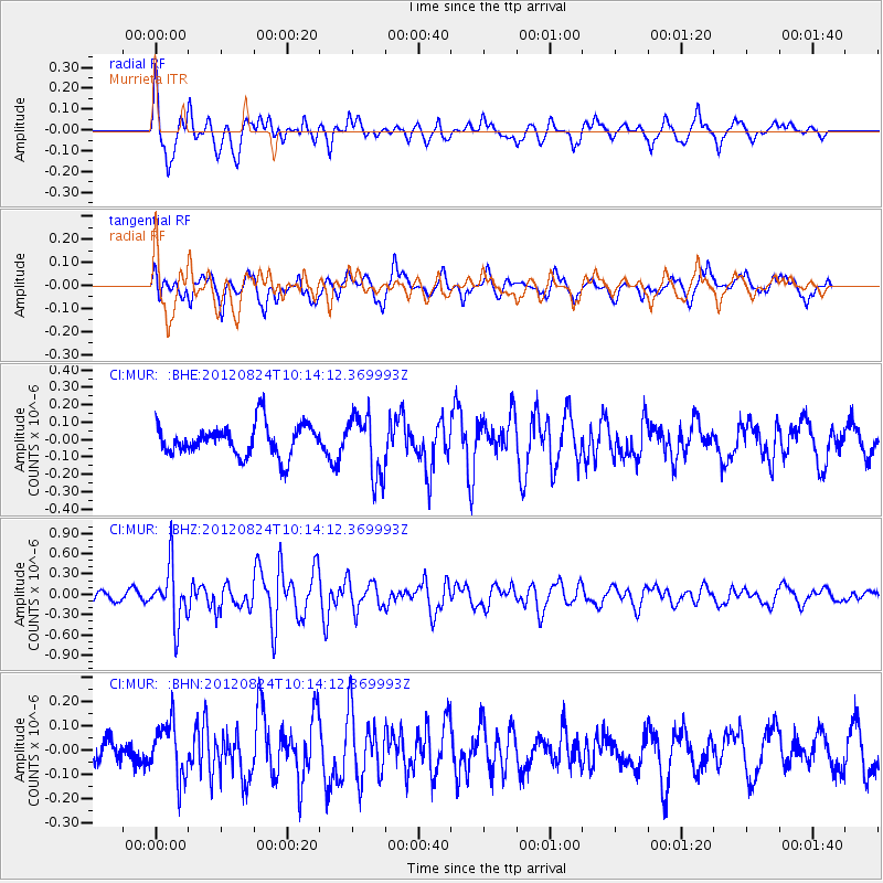
Signal To Noise
| Channel | StoN | STA | LTA |
| CI:MUR: :BHZ:20120824T10:14:12.369993Z | 7.165738 | 4.1223637E-7 | 5.752881E-8 |
| CI:MUR: :BHN:20120824T10:14:12.369993Z | 2.0627067 | 1.12532256E-7 | 5.4555624E-8 |
| CI:MUR: :BHE:20120824T10:14:12.369993Z | 1.9690564 | 1.782512E-7 | 9.052621E-8 |
| Arrivals |
| Ps | |
| PpPs | |
| PsPs/PpSs | |


