You are here: Home > Network List > TA - USArray Transportable Network (new EarthScope stations) Stations List
> Station 121A Cookes Peak, Deming, NM, USA > Earthquake Result Viewer
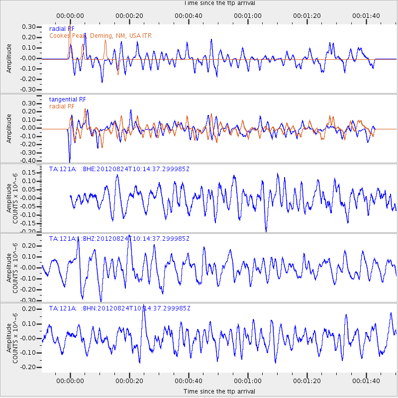
121A Cookes Peak, Deming, NM, USA - Earthquake Result Viewer
*The percent match for this event was below the threshold and hence no stack was calculated.
| Earthquake location: |
South Of Kermadec Islands |
| Earthquake latitude/longitude: |
-33.4/-179.5 |
| Earthquake time(UTC): |
2012/08/24 (237) 10:01:53 GMT |
| Earthquake Depth: |
38 km |
| Earthquake Magnitude: |
5.6 MW, 5.1 MS, 5.2 MB, 5.8 MW |
| Earthquake Catalog/Contributor: |
WHDF/NEIC |
|
| Network: |
TA USArray Transportable Network (new EarthScope stations) |
| Station: |
121A Cookes Peak, Deming, NM, USA |
| Lat/Lon: |
32.53 N/107.79 W |
| Elevation: |
1652 m |
|
| Distance: |
94.1 deg |
| Az: |
53.545 deg |
| Baz: |
232.77 deg |
| Ray Param: |
$rayparam |
*The percent match for this event was below the threshold and hence was not used in the summary stack. |
|
| Radial Match: |
58.063713 % |
| Radial Bump: |
400 |
| Transverse Match: |
58.661194 % |
| Transverse Bump: |
400 |
| SOD ConfigId: |
469095 |
| Insert Time: |
2013-02-22 08:05:26.644 +0000 |
| GWidth: |
2.5 |
| Max Bumps: |
400 |
| Tol: |
0.001 |
|
Signal To Noise
| Channel | StoN | STA | LTA |
| TA:121A: :BHZ:20120824T10:14:37.299985Z | 2.722945 | 1.5096713E-7 | 5.5442587E-8 |
| TA:121A: :BHN:20120824T10:14:37.299985Z | 0.8141652 | 4.228172E-8 | 5.1932602E-8 |
| TA:121A: :BHE:20120824T10:14:37.299985Z | 1.2522807 | 6.572359E-8 | 5.248311E-8 |
| Arrivals |
| Ps | |
| PpPs | |
| PsPs/PpSs | |


