You are here: Home > Network List > G - GEOSCOPE Stations List
> Station TAOE Taiohae, Marquises islands > Earthquake Result Viewer
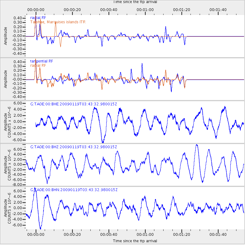
TAOE Taiohae, Marquises islands - Earthquake Result Viewer
*The percent match for this event was below the threshold and hence no stack was calculated.
| Earthquake location: |
Southeast Of Loyalty Islands |
| Earthquake latitude/longitude: |
-22.6/170.9 |
| Earthquake time(UTC): |
2009/01/19 (019) 03:35:18 GMT |
| Earthquake Depth: |
12 km |
| Earthquake Magnitude: |
5.7 MB, 6.4 MS, 6.5 MW, 6.5 MW |
| Earthquake Catalog/Contributor: |
WHDF/NEIC |
|
| Network: |
G GEOSCOPE |
| Station: |
TAOE Taiohae, Marquises islands |
| Lat/Lon: |
8.85 S/140.15 W |
| Elevation: |
800 m |
|
| Distance: |
48.8 deg |
| Az: |
81.855 deg |
| Baz: |
247.776 deg |
| Ray Param: |
$rayparam |
*The percent match for this event was below the threshold and hence was not used in the summary stack. |
|
| Radial Match: |
62.371185 % |
| Radial Bump: |
334 |
| Transverse Match: |
78.29782 % |
| Transverse Bump: |
361 |
| SOD ConfigId: |
2658 |
| Insert Time: |
2010-02-27 00:37:13.830 +0000 |
| GWidth: |
2.5 |
| Max Bumps: |
400 |
| Tol: |
0.001 |
|
Signal To Noise
| Channel | StoN | STA | LTA |
| G:TAOE:00:BHZ:20090119T03:43:32.980015Z | 1.4023199 | 2.226477E-6 | 1.5877098E-6 |
| G:TAOE:00:BHN:20090119T03:43:32.980015Z | 1.7587485 | 4.9093196E-6 | 2.7913711E-6 |
| G:TAOE:00:BHE:20090119T03:43:32.980015Z | 2.717657 | 3.304775E-6 | 1.2160383E-6 |
| Arrivals |
| Ps | |
| PpPs | |
| PsPs/PpSs | |


