You are here: Home > Network List > CB - China National Seismic Network Stations List
> Station HEH Heihe,Heilongjiang Province > Earthquake Result Viewer
HEH Heihe,Heilongjiang Province - Earthquake Result Viewer
| Earthquake location: |
Northern Molucca Sea |
| Earthquake latitude/longitude: |
2.2/126.8 |
| Earthquake time(UTC): |
2012/08/26 (239) 15:05:37 GMT |
| Earthquake Depth: |
91 km |
| Earthquake Magnitude: |
6.3 MB, 6.6 MW, 6.6 MW |
| Earthquake Catalog/Contributor: |
WHDF/NEIC |
|
| Network: |
CB China National Seismic Network |
| Station: |
HEH Heihe,Heilongjiang Province |
| Lat/Lon: |
50.25 N/127.41 E |
| Elevation: |
165 m |
|
| Distance: |
47.9 deg |
| Az: |
0.496 deg |
| Baz: |
180.772 deg |
| Ray Param: |
0.069419995 |
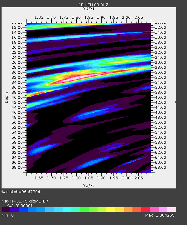
| Estimated Moho Depth: |
31.75 km |
| Estimated Crust Vp/Vs: |
1.81 |
| Assumed Crust Vp: |
6.419 km/s |
| Estimated Crust Vs: |
3.547 km/s |
| Estimated Crust Poisson's Ratio: |
0.28 |
|
| Radial Match: |
96.67394 % |
| Radial Bump: |
280 |
| Transverse Match: |
82.45122 % |
| Transverse Bump: |
400 |
| SOD ConfigId: |
469095 |
| Insert Time: |
2013-02-22 08:11:42.094 +0000 |
| GWidth: |
2.5 |
| Max Bumps: |
400 |
| Tol: |
0.001 |
|
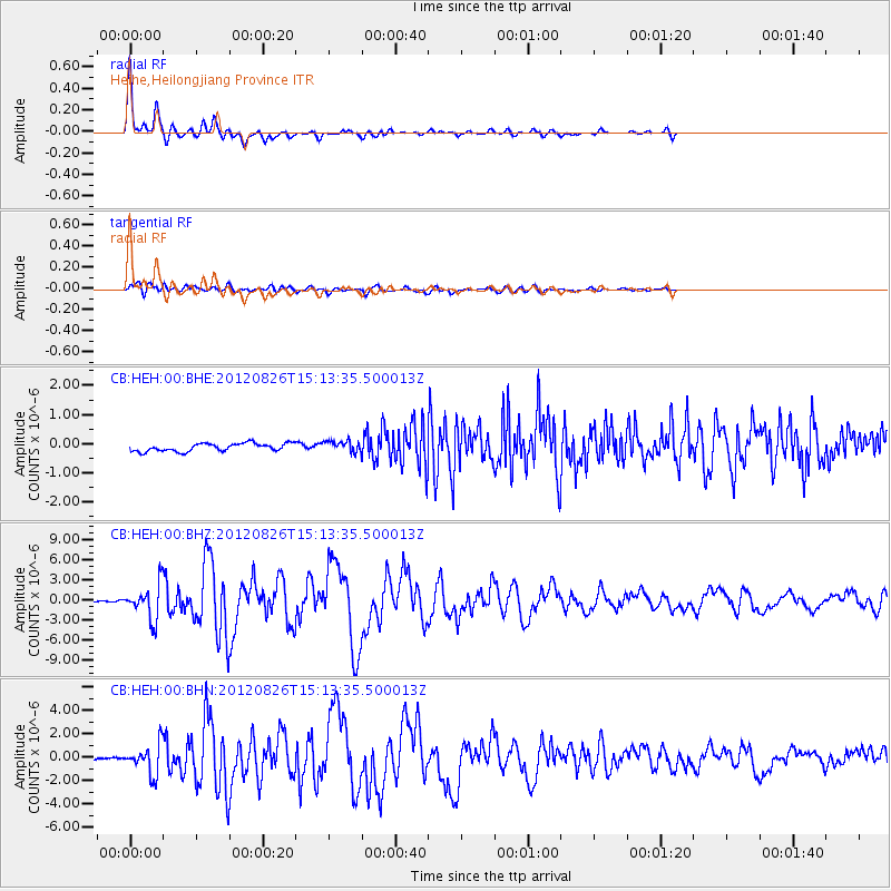
Signal To Noise
| Channel | StoN | STA | LTA |
| CB:HEH:00:BHZ:20120826T15:13:35.500013Z | 26.604073 | 2.5026118E-6 | 9.4068746E-8 |
| CB:HEH:00:BHN:20120826T15:13:35.500013Z | 4.739386 | 1.2692423E-6 | 2.678073E-7 |
| CB:HEH:00:BHE:20120826T15:13:35.500013Z | 1.4364563 | 1.9374835E-7 | 1.3487939E-7 |
| Arrivals |
| Ps | 4.2 SECOND |
| PpPs | 13 SECOND |
| PsPs/PpSs | 17 SECOND |


