You are here: Home > Network List > IU - Global Seismograph Network (GSN - IRIS/USGS) Stations List
> Station TIXI Tiksi, Russia > Earthquake Result Viewer
TIXI Tiksi, Russia - Earthquake Result Viewer
| Earthquake location: |
Northern Molucca Sea |
| Earthquake latitude/longitude: |
2.2/126.8 |
| Earthquake time(UTC): |
2012/08/26 (239) 15:05:37 GMT |
| Earthquake Depth: |
91 km |
| Earthquake Magnitude: |
6.3 MB, 6.6 MW, 6.6 MW |
| Earthquake Catalog/Contributor: |
WHDF/NEIC |
|
| Network: |
IU Global Seismograph Network (GSN - IRIS/USGS) |
| Station: |
TIXI Tiksi, Russia |
| Lat/Lon: |
71.63 N/128.87 E |
| Elevation: |
40 m |
|
| Distance: |
69.4 deg |
| Az: |
0.687 deg |
| Baz: |
182.167 deg |
| Ray Param: |
0.055475693 |
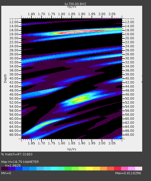
| Estimated Moho Depth: |
16.75 km |
| Estimated Crust Vp/Vs: |
1.86 |
| Assumed Crust Vp: |
6.552 km/s |
| Estimated Crust Vs: |
3.518 km/s |
| Estimated Crust Poisson's Ratio: |
0.30 |
|
| Radial Match: |
97.31683 % |
| Radial Bump: |
400 |
| Transverse Match: |
92.755356 % |
| Transverse Bump: |
400 |
| SOD ConfigId: |
469095 |
| Insert Time: |
2013-02-22 08:12:46.850 +0000 |
| GWidth: |
2.5 |
| Max Bumps: |
400 |
| Tol: |
0.001 |
|
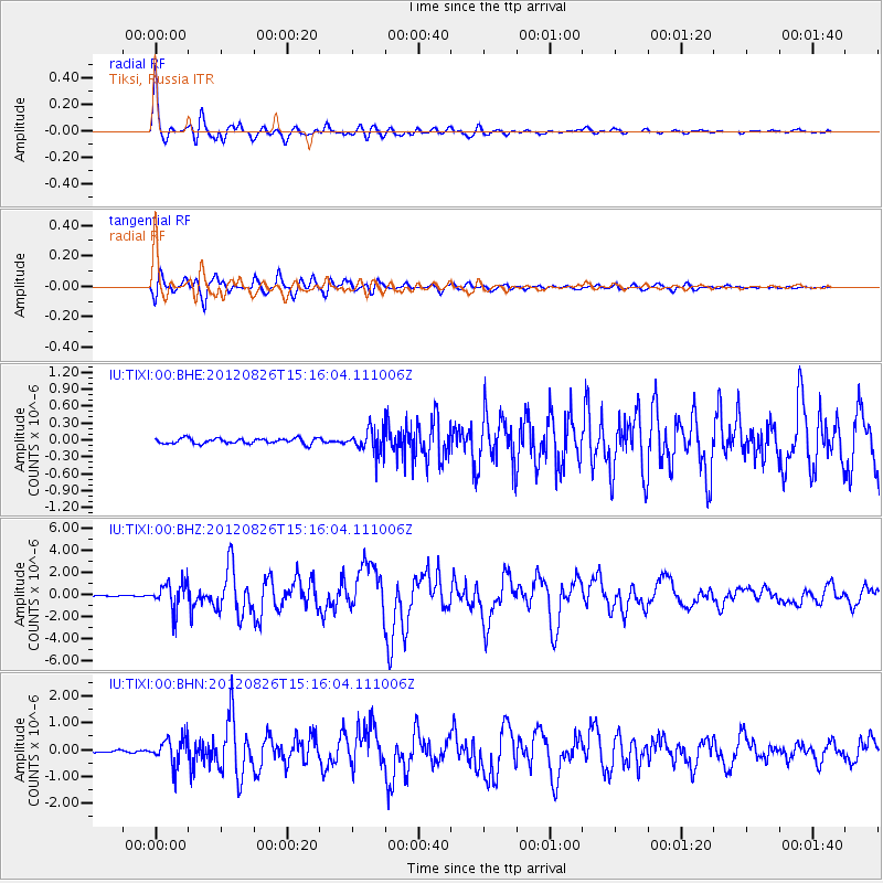
Signal To Noise
| Channel | StoN | STA | LTA |
| IU:TIXI:00:BHZ:20120826T15:16:04.111006Z | 20.19912 | 1.2298425E-6 | 6.088595E-8 |
| IU:TIXI:00:BHN:20120826T15:16:04.111006Z | 11.326681 | 4.986185E-7 | 4.4021583E-8 |
| IU:TIXI:00:BHE:20120826T15:16:04.111006Z | 4.4185057 | 2.0873698E-7 | 4.7241528E-8 |
| Arrivals |
| Ps | 2.3 SECOND |
| PpPs | 7.1 SECOND |
| PsPs/PpSs | 9.3 SECOND |


