You are here: Home > Network List > ND - New CaleDonia Broadband Seismic Network Stations List
> Station OUENC Ouen island, New Caledonia > Earthquake Result Viewer
OUENC Ouen island, New Caledonia - Earthquake Result Viewer
| Earthquake location: |
Northern Molucca Sea |
| Earthquake latitude/longitude: |
2.2/126.8 |
| Earthquake time(UTC): |
2012/08/26 (239) 15:05:37 GMT |
| Earthquake Depth: |
91 km |
| Earthquake Magnitude: |
6.3 MB, 6.6 MW, 6.6 MW |
| Earthquake Catalog/Contributor: |
WHDF/NEIC |
|
| Network: |
ND New CaleDonia Broadband Seismic Network |
| Station: |
OUENC Ouen island, New Caledonia |
| Lat/Lon: |
22.42 S/166.84 E |
| Elevation: |
115 m |
|
| Distance: |
46.1 deg |
| Az: |
124.302 deg |
| Baz: |
296.862 deg |
| Ray Param: |
0.07058782 |
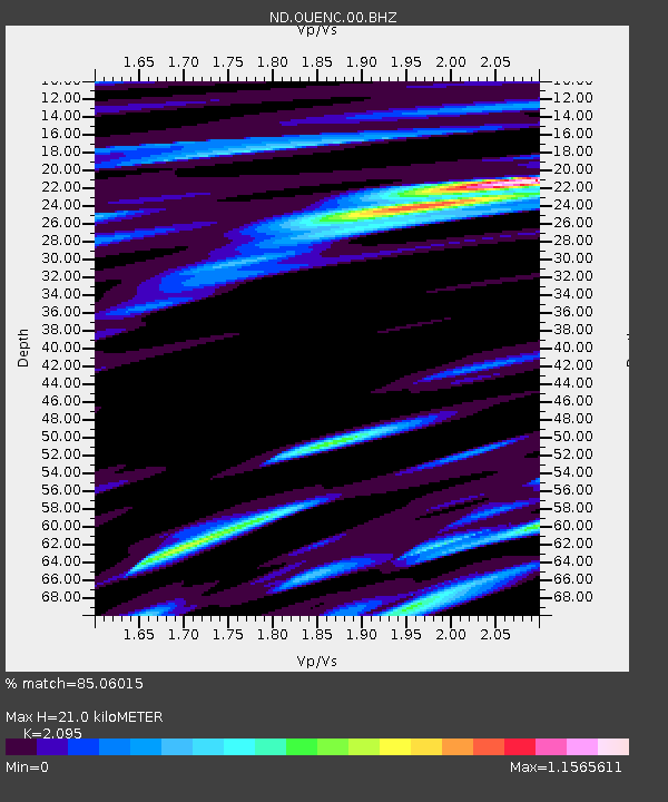
| Estimated Moho Depth: |
21.0 km |
| Estimated Crust Vp/Vs: |
2.10 |
| Assumed Crust Vp: |
5.14 km/s |
| Estimated Crust Vs: |
2.453 km/s |
| Estimated Crust Poisson's Ratio: |
0.35 |
|
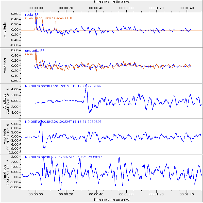
| Radial Match: |
85.06015 % |
| Radial Bump: |
400 |
| Transverse Match: |
76.86944 % |
| Transverse Bump: |
400 |
| SOD ConfigId: |
469095 |
| Insert Time: |
2013-02-22 08:13:39.162 +0000 |
| GWidth: |
2.5 |
| Max Bumps: |
400 |
| Tol: |
0.001 |
|
Signal To Noise
| Channel | StoN | STA | LTA |
| ND:OUENC:00:BHZ:20120826T15:13:21.293989Z | 28.610973 | 5.2212845E-6 | 1.8249239E-7 |
| ND:OUENC:00:BHN:20120826T15:13:21.293989Z | 2.0971165 | 1.1212846E-6 | 5.346792E-7 |
| ND:OUENC:00:BHE:20120826T15:13:21.293989Z | 7.165192 | 2.4674084E-6 | 3.443604E-7 |
| Arrivals |
| Ps | 4.6 SECOND |
| PpPs | 12 SECOND |
| PsPs/PpSs | 17 SECOND |


