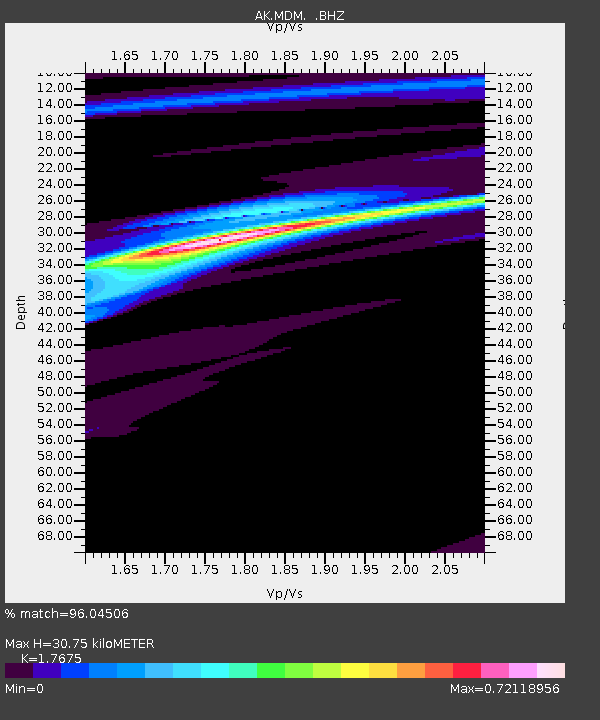
MDM Murphy Dome - Earthquake Result Viewer

Earthquake location: Off Coast Of Central America
Earthquake latitude/longitude: 12.1/-88.6
Earthquake time(UTC): 2012/08/27 (240) 04:37:19 GMT
Earthquake Depth: 28 km
Earthquake Magnitude: 6.0 MB, 6.9 MS, 7.3 MW, 7.4 MW
Earthquake Catalog/Contributor: WHDF/NEIC
Network: AK Alaska Regional Network
Station: MDM Murphy Dome
Lat/Lon: 64.96 N/148.23 W
Elevation: 634 m
Distance: 66.5 deg
Az: 336.385 deg
Baz: 113.011 deg
Ray Param: 0.057563826
Estimated Moho Depth: 30.75 km
Estimated Crust Vp/Vs: 1.77
Assumed Crust Vp: 6.566 km/s
Estimated Crust Vs: 3.715 km/s
Estimated Crust Poisson's Ratio: 0.26
Radial Match: 96.04506 %
Radial Bump: 231
Transverse Match: 75.23727 %
Transverse Bump: 400
SOD ConfigId: 469095
Insert Time: 2013-02-22 08:18:42.756 +0000
GWidth: 2.5
Max Bumps: 400
Tol: 0.001

Signal To Noise

ChannelStoNSTALTA
AK:MDM: :BHZ:20120827T04:47:35.227974Z4.62440352.0175047E-74.362735E-8
AK:MDM: :BHN:20120827T04:47:35.227974Z0.492802621.4168441E-72.8750742E-7
AK:MDM: :BHE:20120827T04:47:35.227974Z5.3131036.177111E-71.16261845E-7
Arrivals
Ps3.8 SECOND
PpPs12 SECOND
PsPs/PpSs16 SECOND