You are here: Home > Network List > CI - Caltech Regional Seismic Network Stations List
> Station MPP McPhearson Peak > Earthquake Result Viewer
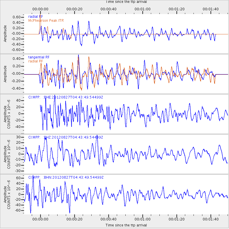
MPP McPhearson Peak - Earthquake Result Viewer
*The percent match for this event was below the threshold and hence no stack was calculated.
| Earthquake location: |
Off Coast Of Central America |
| Earthquake latitude/longitude: |
12.1/-88.6 |
| Earthquake time(UTC): |
2012/08/27 (240) 04:37:19 GMT |
| Earthquake Depth: |
28 km |
| Earthquake Magnitude: |
6.0 MB, 6.9 MS, 7.3 MW, 7.4 MW |
| Earthquake Catalog/Contributor: |
WHDF/NEIC |
|
| Network: |
CI Caltech Regional Seismic Network |
| Station: |
MPP McPhearson Peak |
| Lat/Lon: |
34.89 N/119.81 W |
| Elevation: |
1739 m |
|
| Distance: |
36.3 deg |
| Az: |
313.89 deg |
| Baz: |
120.984 deg |
| Ray Param: |
$rayparam |
*The percent match for this event was below the threshold and hence was not used in the summary stack. |
|
| Radial Match: |
56.628807 % |
| Radial Bump: |
400 |
| Transverse Match: |
58.79368 % |
| Transverse Bump: |
400 |
| SOD ConfigId: |
469095 |
| Insert Time: |
2013-02-22 08:21:29.256 +0000 |
| GWidth: |
2.5 |
| Max Bumps: |
400 |
| Tol: |
0.001 |
|
Signal To Noise
| Channel | StoN | STA | LTA |
| CI:MPP: :BHZ:20120827T04:43:49.54499Z | 1.0460563 | 1.598447E-5 | 1.5280697E-5 |
| CI:MPP: :BHN:20120827T04:43:49.54499Z | 1.3658049 | 2.5822155E-5 | 1.8906181E-5 |
| CI:MPP: :BHE:20120827T04:43:49.54499Z | 0.74074787 | 1.6608903E-5 | 2.2421804E-5 |
| Arrivals |
| Ps | |
| PpPs | |
| PsPs/PpSs | |


