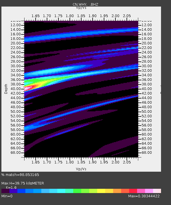
WHY Whitehorse, YT - Earthquake Result Viewer

Earthquake location: Off Coast Of Central America
Earthquake latitude/longitude: 12.1/-88.6
Earthquake time(UTC): 2012/08/27 (240) 04:37:19 GMT
Earthquake Depth: 28 km
Earthquake Magnitude: 6.0 MB, 6.9 MS, 7.3 MW, 7.4 MW
Earthquake Catalog/Contributor: WHDF/NEIC
Network: CN Canadian National Seismograph Network
Station: WHY Whitehorse, YT
Lat/Lon: 60.66 N/134.88 W
Elevation: 1292 m
Distance: 59.0 deg
Az: 335.467 deg
Baz: 124.465 deg
Ray Param: 0.062416468
Estimated Moho Depth: 39.75 km
Estimated Crust Vp/Vs: 1.60
Assumed Crust Vp: 6.419 km/s
Estimated Crust Vs: 4.012 km/s
Estimated Crust Poisson's Ratio: 0.18
Radial Match: 98.853165 %
Radial Bump: 185
Transverse Match: 78.96246 %
Transverse Bump: 400
SOD ConfigId: 469095
Insert Time: 2013-02-22 08:22:04.064 +0000
GWidth: 2.5
Max Bumps: 400
Tol: 0.001

Signal To Noise

ChannelStoNSTALTA
CN:WHY: :BHZ:20120827T04:46:45.82502Z2.74214941.44428E-75.2669638E-8
CN:WHY: :BHN:20120827T04:46:45.82502Z1.35766886.09933E-84.4925024E-8
CN:WHY: :BHE:20120827T04:46:45.82502Z2.02435769.7271375E-84.805049E-8
Arrivals
Ps3.9 SECOND
PpPs15 SECOND
PsPs/PpSs19 SECOND