You are here: Home > Network List > IW - Intermountain West Stations List
> Station PLID Pearl Lake, Idaho, USA > Earthquake Result Viewer
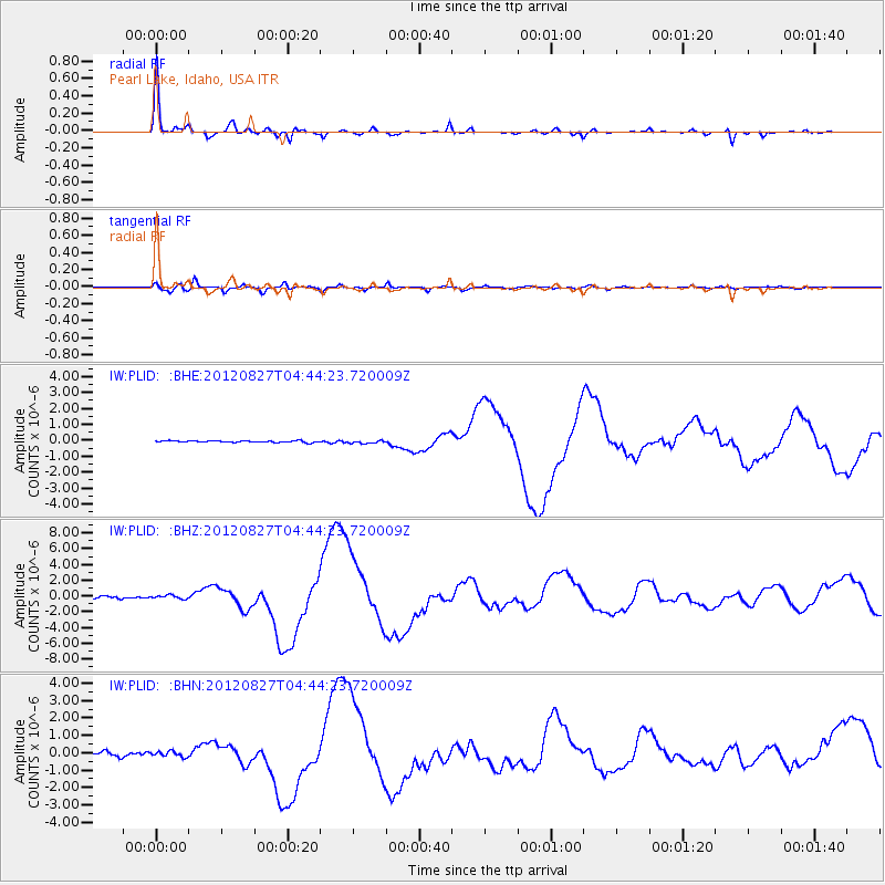
PLID Pearl Lake, Idaho, USA - Earthquake Result Viewer

| Earthquake location: |
Off Coast Of Central America |
| Earthquake latitude/longitude: |
12.1/-88.6 |
| Earthquake time(UTC): |
2012/08/27 (240) 04:37:19 GMT |
| Earthquake Depth: |
28 km |
| Earthquake Magnitude: |
6.0 MB, 6.9 MS, 7.3 MW, 7.4 MW |
| Earthquake Catalog/Contributor: |
WHDF/NEIC |
|
| Network: |
IW Intermountain West |
| Station: |
PLID Pearl Lake, Idaho, USA |
| Lat/Lon: |
45.09 N/116.00 W |
| Elevation: |
2164 m |
|
| Distance: |
40.3 deg |
| Az: |
329.734 deg |
| Baz: |
135.91 deg |
| Ray Param: |
0.07442225 |
| Estimated Moho Depth: |
33.75 km |
| Estimated Crust Vp/Vs: |
1.89 |
| Assumed Crust Vp: |
6.571 km/s |
| Estimated Crust Vs: |
3.477 km/s |
| Estimated Crust Poisson's Ratio: |
0.31 |
|
| Radial Match: |
97.953125 % |
| Radial Bump: |
228 |
| Transverse Match: |
89.449745 % |
| Transverse Bump: |
400 |
| SOD ConfigId: |
469095 |
| Insert Time: |
2013-02-22 08:23:59.645 +0000 |
| GWidth: |
2.5 |
| Max Bumps: |
400 |
| Tol: |
0.001 |
|
Signal To Noise
| Channel | StoN | STA | LTA |
| IW:PLID: :BHZ:20120827T04:44:23.720009Z | 1.8718415 | 2.519031E-7 | 1.3457502E-7 |
| IW:PLID: :BHN:20120827T04:44:23.720009Z | 1.240916 | 1.5829102E-7 | 1.2755982E-7 |
| IW:PLID: :BHE:20120827T04:44:23.720009Z | 1.8850243 | 9.644676E-8 | 5.1164733E-8 |
| Arrivals |
| Ps | 4.9 SECOND |
| PpPs | 14 SECOND |
| PsPs/PpSs | 19 SECOND |


