You are here: Home > Network List > TA - USArray Transportable Network (new EarthScope stations) Stations List
> Station H17A Grant Village (NPS), Yellowstone Nt. Park, WY, USA > Earthquake Result Viewer
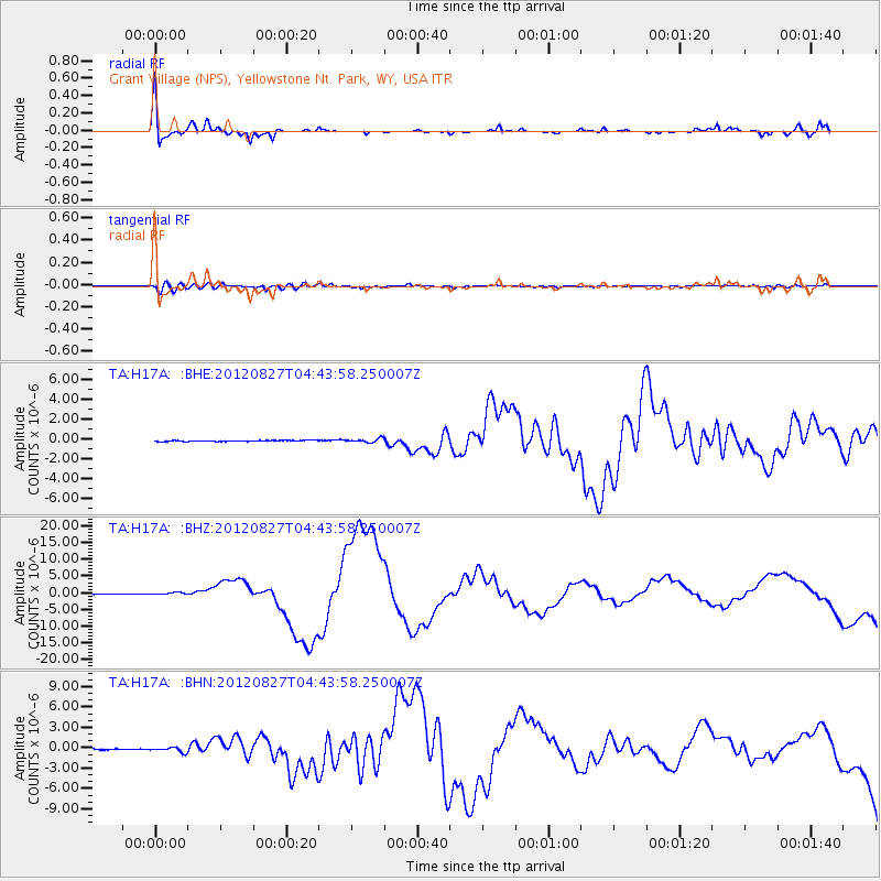
H17A Grant Village (NPS), Yellowstone Nt. Park, WY, USA - Earthquake Result Viewer
*The percent match for this event was below the threshold and hence no stack was calculated.
| Earthquake location: |
Off Coast Of Central America |
| Earthquake latitude/longitude: |
12.1/-88.6 |
| Earthquake time(UTC): |
2012/08/27 (240) 04:37:19 GMT |
| Earthquake Depth: |
28 km |
| Earthquake Magnitude: |
6.0 MB, 6.9 MS, 7.3 MW, 7.4 MW |
| Earthquake Catalog/Contributor: |
WHDF/NEIC |
|
| Network: |
TA USArray Transportable Network (new EarthScope stations) |
| Station: |
H17A Grant Village (NPS), Yellowstone Nt. Park, WY, USA |
| Lat/Lon: |
44.40 N/110.58 W |
| Elevation: |
2400 m |
|
| Distance: |
37.3 deg |
| Az: |
333.695 deg |
| Baz: |
142.806 deg |
| Ray Param: |
$rayparam |
*The percent match for this event was below the threshold and hence was not used in the summary stack. |
|
| Radial Match: |
76.15428 % |
| Radial Bump: |
400 |
| Transverse Match: |
60.52534 % |
| Transverse Bump: |
400 |
| SOD ConfigId: |
469095 |
| Insert Time: |
2013-02-22 08:25:08.739 +0000 |
| GWidth: |
2.5 |
| Max Bumps: |
400 |
| Tol: |
0.001 |
|
Signal To Noise
| Channel | StoN | STA | LTA |
| TA:H17A: :BHZ:20120827T04:43:58.250007Z | 1.5851964 | 2.5418655E-7 | 1.6035018E-7 |
| TA:H17A: :BHN:20120827T04:43:58.250007Z | 5.1134324 | 3.389869E-7 | 6.629341E-8 |
| TA:H17A: :BHE:20120827T04:43:58.250007Z | 3.4145403 | 1.9680273E-7 | 5.763667E-8 |
| Arrivals |
| Ps | |
| PpPs | |
| PsPs/PpSs | |


