You are here: Home > Network List > TA - USArray Transportable Network (new EarthScope stations) Stations List
> Station H37A Dierke Farm, Cannon Falls, MN, USA > Earthquake Result Viewer
H37A Dierke Farm, Cannon Falls, MN, USA - Earthquake Result Viewer
| Earthquake location: |
Off Coast Of Central America |
| Earthquake latitude/longitude: |
12.1/-88.6 |
| Earthquake time(UTC): |
2012/08/27 (240) 04:37:19 GMT |
| Earthquake Depth: |
28 km |
| Earthquake Magnitude: |
6.0 MB, 6.9 MS, 7.3 MW, 7.4 MW |
| Earthquake Catalog/Contributor: |
WHDF/NEIC |
|
| Network: |
TA USArray Transportable Network (new EarthScope stations) |
| Station: |
H37A Dierke Farm, Cannon Falls, MN, USA |
| Lat/Lon: |
44.58 N/92.92 W |
| Elevation: |
321 m |
|
| Distance: |
32.5 deg |
| Az: |
354.246 deg |
| Baz: |
172.114 deg |
| Ray Param: |
0.078569666 |
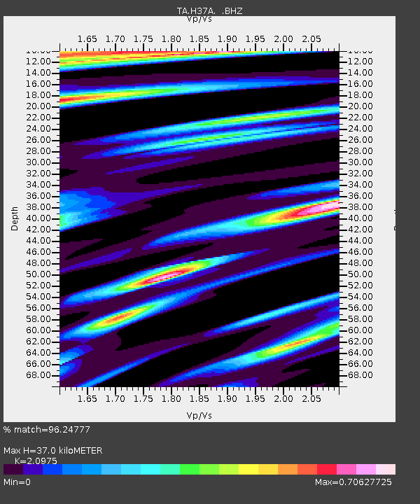
| Estimated Moho Depth: |
37.0 km |
| Estimated Crust Vp/Vs: |
2.10 |
| Assumed Crust Vp: |
6.571 km/s |
| Estimated Crust Vs: |
3.133 km/s |
| Estimated Crust Poisson's Ratio: |
0.35 |
|
| Radial Match: |
96.24777 % |
| Radial Bump: |
400 |
| Transverse Match: |
76.74644 % |
| Transverse Bump: |
400 |
| SOD ConfigId: |
469095 |
| Insert Time: |
2013-02-22 08:26:34.763 +0000 |
| GWidth: |
2.5 |
| Max Bumps: |
400 |
| Tol: |
0.001 |
|

Signal To Noise
| Channel | StoN | STA | LTA |
| TA:H37A: :BHZ:20120827T04:43:17.525001Z | 2.8306847 | 8.3381593E-7 | 2.9456334E-7 |
| TA:H37A: :BHN:20120827T04:43:17.525001Z | 2.9357798 | 7.926216E-7 | 2.6998674E-7 |
| TA:H37A: :BHE:20120827T04:43:17.525001Z | 0.6590031 | 1.5013804E-7 | 2.2782598E-7 |
| Arrivals |
| Ps | 6.6 SECOND |
| PpPs | 16 SECOND |
| PsPs/PpSs | 23 SECOND |


