You are here: Home > Network List > TA - USArray Transportable Network (new EarthScope stations) Stations List
> Station G38A Ridgeland, WI, USA > Earthquake Result Viewer
G38A Ridgeland, WI, USA - Earthquake Result Viewer
| Earthquake location: |
Off Coast Of Central America |
| Earthquake latitude/longitude: |
12.1/-88.6 |
| Earthquake time(UTC): |
2012/08/27 (240) 04:37:19 GMT |
| Earthquake Depth: |
28 km |
| Earthquake Magnitude: |
6.0 MB, 6.9 MS, 7.3 MW, 7.4 MW |
| Earthquake Catalog/Contributor: |
WHDF/NEIC |
|
| Network: |
TA USArray Transportable Network (new EarthScope stations) |
| Station: |
G38A Ridgeland, WI, USA |
| Lat/Lon: |
45.17 N/91.85 W |
| Elevation: |
370 m |
|
| Distance: |
33.0 deg |
| Az: |
355.762 deg |
| Baz: |
174.136 deg |
| Ray Param: |
0.078352414 |
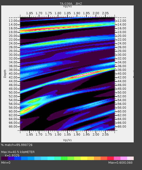
| Estimated Moho Depth: |
40.5 km |
| Estimated Crust Vp/Vs: |
1.93 |
| Assumed Crust Vp: |
6.571 km/s |
| Estimated Crust Vs: |
3.4 km/s |
| Estimated Crust Poisson's Ratio: |
0.32 |
|
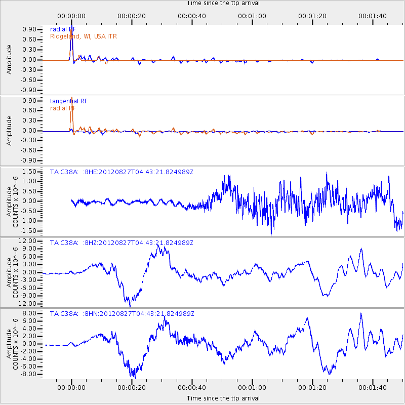
| Radial Match: |
95.998726 % |
| Radial Bump: |
284 |
| Transverse Match: |
70.654655 % |
| Transverse Bump: |
400 |
| SOD ConfigId: |
469095 |
| Insert Time: |
2013-02-22 08:28:15.131 +0000 |
| GWidth: |
2.5 |
| Max Bumps: |
400 |
| Tol: |
0.001 |
|
Signal To Noise
| Channel | StoN | STA | LTA |
| TA:G38A: :BHZ:20120827T04:43:21.824989Z | 5.2125735 | 6.714188E-7 | 1.2880754E-7 |
| TA:G38A: :BHN:20120827T04:43:21.824989Z | 5.709578 | 5.273545E-7 | 9.236313E-8 |
| TA:G38A: :BHE:20120827T04:43:21.824989Z | 1.3242313 | 1.01030125E-7 | 7.629342E-8 |
| Arrivals |
| Ps | 6.2 SECOND |
| PpPs | 17 SECOND |
| PsPs/PpSs | 23 SECOND |


