You are here: Home > Network List > G - GEOSCOPE Stations List
> Station UNM Unam,Mexico > Earthquake Result Viewer
UNM Unam,Mexico - Earthquake Result Viewer

| Earthquake location: |
Kuril Islands |
| Earthquake latitude/longitude: |
45.5/151.0 |
| Earthquake time(UTC): |
1991/12/22 (356) 08:43:13 GMT |
| Earthquake Depth: |
26 km |
| Earthquake Magnitude: |
6.3 MB, 7.4 MS |
| Earthquake Catalog/Contributor: |
WHDF/NEIC |
|
| Network: |
G GEOSCOPE |
| Station: |
UNM Unam,Mexico |
| Lat/Lon: |
19.33 N/99.18 W |
| Elevation: |
2280 m |
|
| Distance: |
89.5 deg |
| Az: |
62.708 deg |
| Baz: |
318.536 deg |
| Ray Param: |
0.041789014 |
| Estimated Moho Depth: |
13.5 km |
| Estimated Crust Vp/Vs: |
2.03 |
| Assumed Crust Vp: |
6.597 km/s |
| Estimated Crust Vs: |
3.254 km/s |
| Estimated Crust Poisson's Ratio: |
0.34 |
|
| Radial Match: |
90.96267 % |
| Radial Bump: |
387 |
| Transverse Match: |
84.76104 % |
| Transverse Bump: |
393 |
| SOD ConfigId: |
16938 |
| Insert Time: |
2010-02-27 00:37:38.089 +0000 |
| GWidth: |
2.5 |
| Max Bumps: |
400 |
| Tol: |
0.001 |
|
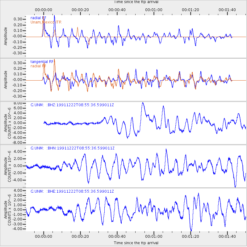
Signal To Noise
| Channel | StoN | STA | LTA |
| G:UNM: :BHN:19911222T08:55:36.599011Z | 0.7589602 | 3.4918452E-7 | 4.600828E-7 |
| G:UNM: :BHE:19911222T08:55:36.599011Z | 0.72628266 | 3.482226E-7 | 4.794588E-7 |
| G:UNM: :BHZ:19911222T08:55:36.599011Z | 4.4823785 | 1.2164501E-6 | 2.7138495E-7 |
| Arrivals |
| Ps | 2.1 SECOND |
| PpPs | 6.1 SECOND |
| PsPs/PpSs | 8.2 SECOND |


