You are here: Home > Network List > TA - USArray Transportable Network (new EarthScope stations) Stations List
> Station E39A Mellen, WI, USA > Earthquake Result Viewer
E39A Mellen, WI, USA - Earthquake Result Viewer
| Earthquake location: |
Off Coast Of Central America |
| Earthquake latitude/longitude: |
12.1/-88.6 |
| Earthquake time(UTC): |
2012/08/27 (240) 04:37:19 GMT |
| Earthquake Depth: |
28 km |
| Earthquake Magnitude: |
6.0 MB, 6.9 MS, 7.3 MW, 7.4 MW |
| Earthquake Catalog/Contributor: |
WHDF/NEIC |
|
| Network: |
TA USArray Transportable Network (new EarthScope stations) |
| Station: |
E39A Mellen, WI, USA |
| Lat/Lon: |
46.38 N/90.56 W |
| Elevation: |
426 m |
|
| Distance: |
34.2 deg |
| Az: |
357.576 deg |
| Baz: |
176.576 deg |
| Ray Param: |
0.07783167 |
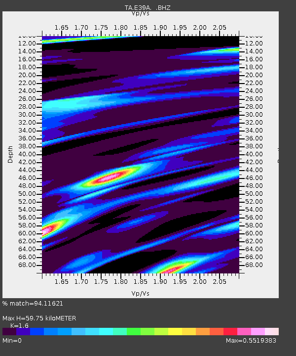
| Estimated Moho Depth: |
59.75 km |
| Estimated Crust Vp/Vs: |
1.60 |
| Assumed Crust Vp: |
6.467 km/s |
| Estimated Crust Vs: |
4.042 km/s |
| Estimated Crust Poisson's Ratio: |
0.18 |
|
| Radial Match: |
94.11621 % |
| Radial Bump: |
318 |
| Transverse Match: |
71.741776 % |
| Transverse Bump: |
400 |
| SOD ConfigId: |
469095 |
| Insert Time: |
2013-02-22 08:28:59.438 +0000 |
| GWidth: |
2.5 |
| Max Bumps: |
400 |
| Tol: |
0.001 |
|

Signal To Noise
| Channel | StoN | STA | LTA |
| TA:E39A: :BHZ:20120827T04:43:31.650001Z | 8.62741 | 8.9906877E-7 | 1.04210734E-7 |
| TA:E39A: :BHN:20120827T04:43:31.650001Z | 5.094396 | 5.390863E-7 | 1.0581947E-7 |
| TA:E39A: :BHE:20120827T04:43:31.650001Z | 1.1219418 | 6.466027E-8 | 5.7632462E-8 |
| Arrivals |
| Ps | 6.0 SECOND |
| PpPs | 22 SECOND |
| PsPs/PpSs | 28 SECOND |


