You are here: Home > Network List > G - GEOSCOPE Stations List
> Station UNM Unam,Mexico > Earthquake Result Viewer
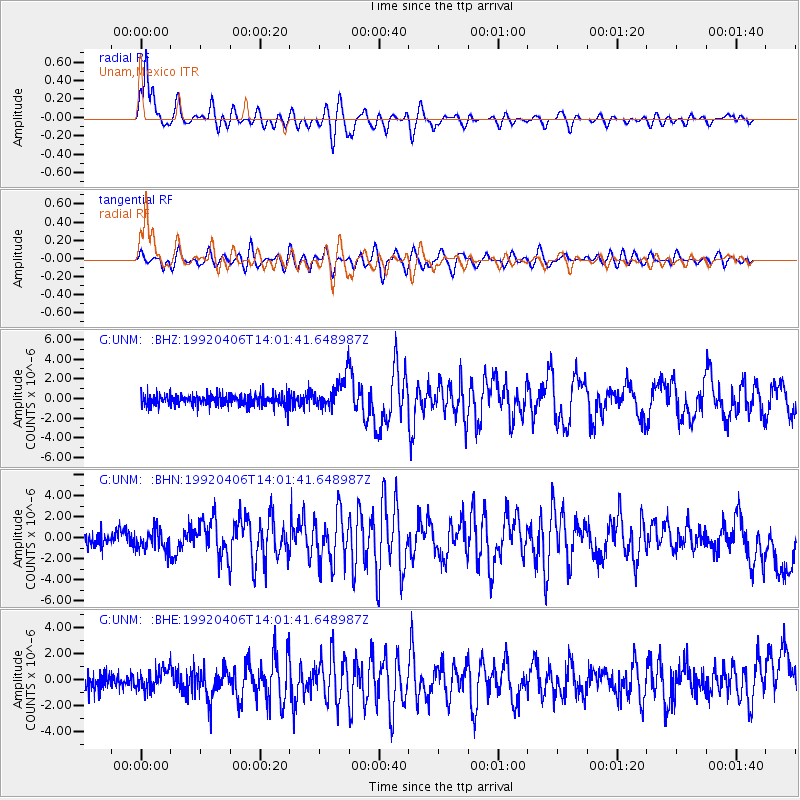
UNM Unam,Mexico - Earthquake Result Viewer

| Earthquake location: |
Vancouver Island, Canada Region |
| Earthquake latitude/longitude: |
50.7/-130.3 |
| Earthquake time(UTC): |
1992/04/06 (097) 13:54:39 GMT |
| Earthquake Depth: |
10 km |
| Earthquake Magnitude: |
6.0 MB, 6.8 MS |
| Earthquake Catalog/Contributor: |
WHDF/NEIC |
|
| Network: |
G GEOSCOPE |
| Station: |
UNM Unam,Mexico |
| Lat/Lon: |
19.33 N/99.18 W |
| Elevation: |
2280 m |
|
| Distance: |
39.8 deg |
| Az: |
130.38 deg |
| Baz: |
329.114 deg |
| Ray Param: |
0.07478471 |
| Estimated Moho Depth: |
16.25 km |
| Estimated Crust Vp/Vs: |
1.74 |
| Assumed Crust Vp: |
6.597 km/s |
| Estimated Crust Vs: |
3.797 km/s |
| Estimated Crust Poisson's Ratio: |
0.25 |
|
| Radial Match: |
87.887825 % |
| Radial Bump: |
400 |
| Transverse Match: |
55.766636 % |
| Transverse Bump: |
400 |
| SOD ConfigId: |
16938 |
| Insert Time: |
2010-02-27 00:37:40.012 +0000 |
| GWidth: |
2.5 |
| Max Bumps: |
400 |
| Tol: |
0.001 |
|
Signal To Noise
| Channel | StoN | STA | LTA |
| G:UNM: :BHN:19920406T14:01:41.648987Z | 1.1903489 | 9.890963E-7 | 8.3092976E-7 |
| G:UNM: :BHE:19920406T14:01:41.648987Z | 1.2183019 | 7.84778E-7 | 6.4415724E-7 |
| G:UNM: :BHZ:19920406T14:01:41.648987Z | 2.6214046 | 1.5671379E-6 | 5.9782377E-7 |
| Arrivals |
| Ps | 2.0 SECOND |
| PpPs | 6.2 SECOND |
| PsPs/PpSs | 8.2 SECOND |


