You are here: Home > Network List > TA - USArray Transportable Network (new EarthScope stations) Stations List
> Station D41A Chassel, MI, USA > Earthquake Result Viewer
D41A Chassel, MI, USA - Earthquake Result Viewer
| Earthquake location: |
Off Coast Of Central America |
| Earthquake latitude/longitude: |
12.1/-88.6 |
| Earthquake time(UTC): |
2012/08/27 (240) 04:37:19 GMT |
| Earthquake Depth: |
28 km |
| Earthquake Magnitude: |
6.0 MB, 6.9 MS, 7.3 MW, 7.4 MW |
| Earthquake Catalog/Contributor: |
WHDF/NEIC |
|
| Network: |
TA USArray Transportable Network (new EarthScope stations) |
| Station: |
D41A Chassel, MI, USA |
| Lat/Lon: |
47.06 N/88.57 W |
| Elevation: |
271 m |
|
| Distance: |
34.8 deg |
| Az: |
0.029 deg |
| Baz: |
180.042 deg |
| Ray Param: |
0.077504754 |
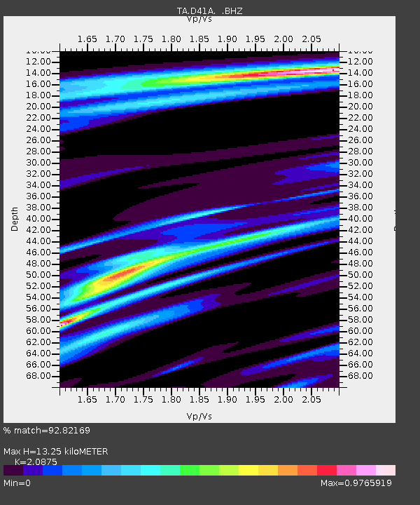
| Estimated Moho Depth: |
13.25 km |
| Estimated Crust Vp/Vs: |
2.09 |
| Assumed Crust Vp: |
6.467 km/s |
| Estimated Crust Vs: |
3.098 km/s |
| Estimated Crust Poisson's Ratio: |
0.35 |
|
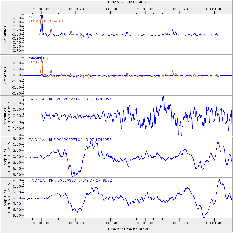
| Radial Match: |
92.82169 % |
| Radial Bump: |
269 |
| Transverse Match: |
73.44185 % |
| Transverse Bump: |
400 |
| SOD ConfigId: |
469095 |
| Insert Time: |
2013-02-22 08:29:21.537 +0000 |
| GWidth: |
2.5 |
| Max Bumps: |
400 |
| Tol: |
0.001 |
|
Signal To Noise
| Channel | StoN | STA | LTA |
| TA:D41A: :BHZ:20120827T04:43:37.174995Z | 3.578773 | 6.6432204E-7 | 1.8562844E-7 |
| TA:D41A: :BHN:20120827T04:43:37.174995Z | 1.7978628 | 3.5842146E-7 | 1.9935973E-7 |
| TA:D41A: :BHE:20120827T04:43:37.174995Z | 0.7356988 | 1.06189454E-7 | 1.4433822E-7 |
| Arrivals |
| Ps | 2.4 SECOND |
| PpPs | 5.9 SECOND |
| PsPs/PpSs | 8.3 SECOND |


