You are here: Home > Network List > G - GEOSCOPE Stations List
> Station UNM Unam,Mexico > Earthquake Result Viewer
UNM Unam,Mexico - Earthquake Result Viewer

| Earthquake location: |
Near Coast Of Northern Calif. |
| Earthquake latitude/longitude: |
40.4/-124.3 |
| Earthquake time(UTC): |
1992/04/25 (116) 18:06:04 GMT |
| Earthquake Depth: |
15 km |
| Earthquake Magnitude: |
6.4 MB, 7.1 MS |
| Earthquake Catalog/Contributor: |
WHDF/NEIC |
|
| Network: |
G GEOSCOPE |
| Station: |
UNM Unam,Mexico |
| Lat/Lon: |
19.33 N/99.18 W |
| Elevation: |
2280 m |
|
| Distance: |
30.1 deg |
| Az: |
126.806 deg |
| Baz: |
319.623 deg |
| Ray Param: |
0.079423316 |
| Estimated Moho Depth: |
59.0 km |
| Estimated Crust Vp/Vs: |
1.66 |
| Assumed Crust Vp: |
6.597 km/s |
| Estimated Crust Vs: |
3.962 km/s |
| Estimated Crust Poisson's Ratio: |
0.22 |
|
| Radial Match: |
88.96956 % |
| Radial Bump: |
400 |
| Transverse Match: |
66.299484 % |
| Transverse Bump: |
400 |
| SOD ConfigId: |
16938 |
| Insert Time: |
2010-02-27 00:37:41.136 +0000 |
| GWidth: |
2.5 |
| Max Bumps: |
400 |
| Tol: |
0.001 |
|
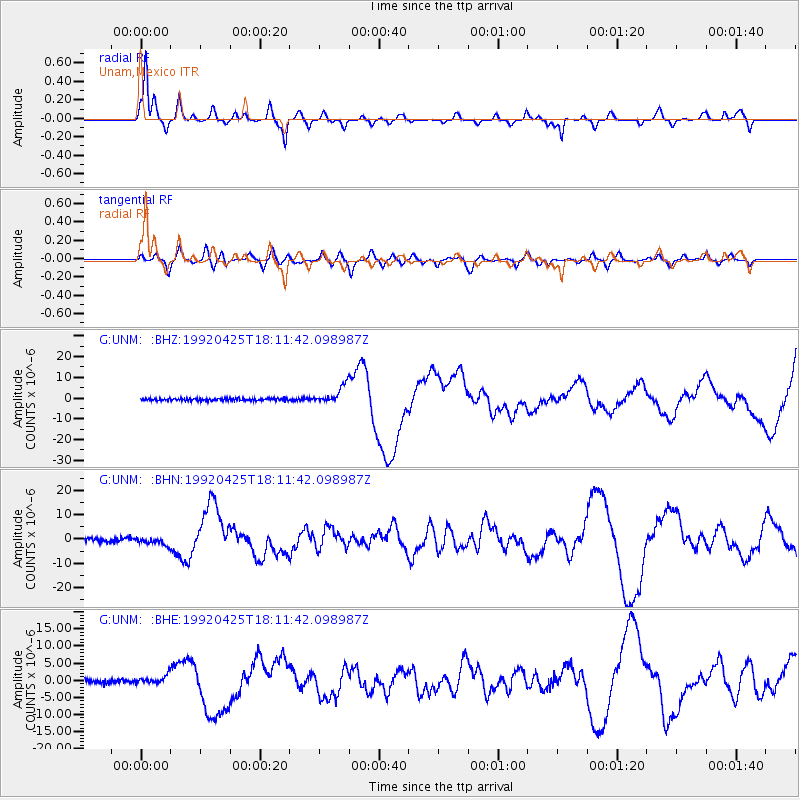
Signal To Noise
| Channel | StoN | STA | LTA |
| G:UNM: :BHN:19920425T18:11:42.098987Z | 2.07849 | 1.5576783E-6 | 7.494278E-7 |
| G:UNM: :BHE:19920425T18:11:42.098987Z | 1.8799472 | 1.171866E-6 | 6.2335045E-7 |
| G:UNM: :BHZ:19920425T18:11:42.098987Z | 7.95268 | 4.3054283E-6 | 5.4138076E-7 |
| Arrivals |
| Ps | 6.5 SECOND |
| PpPs | 22 SECOND |
| PsPs/PpSs | 28 SECOND |


