You are here: Home > Network List > CI - Caltech Regional Seismic Network Stations List
> Station TIN Tinemaha, Big Pine, CA, USA > Earthquake Result Viewer
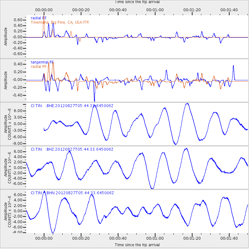
TIN Tinemaha, Big Pine, CA, USA - Earthquake Result Viewer
*The percent match for this event was below the threshold and hence no stack was calculated.
| Earthquake location: |
Off Coast Of Central America |
| Earthquake latitude/longitude: |
12.3/-88.6 |
| Earthquake time(UTC): |
2012/08/27 (240) 05:38:04 GMT |
| Earthquake Depth: |
35 km |
| Earthquake Magnitude: |
5.5 MB |
| Earthquake Catalog/Contributor: |
WHDF/NEIC |
|
| Network: |
CI Caltech Regional Seismic Network |
| Station: |
TIN Tinemaha, Big Pine, CA, USA |
| Lat/Lon: |
37.05 N/118.23 W |
| Elevation: |
1197 m |
|
| Distance: |
36.2 deg |
| Az: |
318.008 deg |
| Baz: |
125.18 deg |
| Ray Param: |
$rayparam |
*The percent match for this event was below the threshold and hence was not used in the summary stack. |
|
| Radial Match: |
29.21146 % |
| Radial Bump: |
308 |
| Transverse Match: |
67.203545 % |
| Transverse Bump: |
388 |
| SOD ConfigId: |
469095 |
| Insert Time: |
2013-02-22 08:33:29.832 +0000 |
| GWidth: |
2.5 |
| Max Bumps: |
400 |
| Tol: |
0.001 |
|
Signal To Noise
| Channel | StoN | STA | LTA |
| CI:TIN: :BHZ:20120827T05:44:33.645006Z | 0.8266436 | 1.6912575E-6 | 2.0459331E-6 |
| CI:TIN: :BHN:20120827T05:44:33.645006Z | 1.8626803 | 5.7344673E-6 | 3.0786105E-6 |
| CI:TIN: :BHE:20120827T05:44:33.645006Z | 2.6549044 | 4.6478194E-6 | 1.7506542E-6 |
| Arrivals |
| Ps | |
| PpPs | |
| PsPs/PpSs | |


