You are here: Home > Network List > G - GEOSCOPE Stations List
> Station UNM Unam,Mexico > Earthquake Result Viewer
UNM Unam,Mexico - Earthquake Result Viewer
| Earthquake location: |
Central Peru |
| Earthquake latitude/longitude: |
-11.6/-76.6 |
| Earthquake time(UTC): |
1993/04/18 (108) 09:16:21 GMT |
| Earthquake Depth: |
90 km |
| Earthquake Magnitude: |
6.1 MB, 5.8 UNKNOWN |
| Earthquake Catalog/Contributor: |
WHDF/NEIC |
|
| Network: |
G GEOSCOPE |
| Station: |
UNM Unam,Mexico |
| Lat/Lon: |
19.33 N/99.18 W |
| Elevation: |
2280 m |
|
| Distance: |
38.0 deg |
| Az: |
323.816 deg |
| Baz: |
142.225 deg |
| Ray Param: |
0.07553342 |
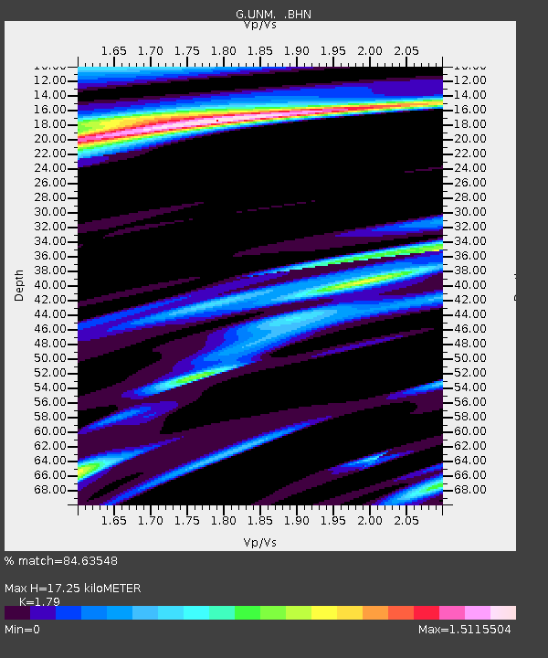
| Estimated Moho Depth: |
17.25 km |
| Estimated Crust Vp/Vs: |
1.79 |
| Assumed Crust Vp: |
6.597 km/s |
| Estimated Crust Vs: |
3.686 km/s |
| Estimated Crust Poisson's Ratio: |
0.27 |
|
| Radial Match: |
84.63548 % |
| Radial Bump: |
400 |
| Transverse Match: |
84.30857 % |
| Transverse Bump: |
400 |
| SOD ConfigId: |
16938 |
| Insert Time: |
2010-02-27 00:37:46.255 +0000 |
| GWidth: |
2.5 |
| Max Bumps: |
400 |
| Tol: |
0.001 |
|

Signal To Noise
| Channel | StoN | STA | LTA |
| G:UNM: :BHN:19930418T09:23:00.450Z | 1.1647084 | 4.8443985E-7 | 4.1593233E-7 |
| G:UNM: :BHE:19930418T09:23:00.450Z | 1.2128122 | 4.3311073E-7 | 3.5711278E-7 |
| G:UNM: :BHZ:19930418T09:23:00.450Z | 8.963302 | 2.4144163E-6 | 2.6936684E-7 |
| Arrivals |
| Ps | 2.2 SECOND |
| PpPs | 6.8 SECOND |
| PsPs/PpSs | 9.0 SECOND |


