You are here: Home > Network List > G - GEOSCOPE Stations List
> Station UNM Unam,Mexico > Earthquake Result Viewer
UNM Unam,Mexico - Earthquake Result Viewer

| Earthquake location: |
Jujuy Province, Argentina |
| Earthquake latitude/longitude: |
-23.2/-66.6 |
| Earthquake time(UTC): |
1993/05/24 (144) 23:51:22 GMT |
| Earthquake Depth: |
238 km |
| Earthquake Magnitude: |
6.2 MB |
| Earthquake Catalog/Contributor: |
WHDF/NEIC |
|
| Network: |
G GEOSCOPE |
| Station: |
UNM Unam,Mexico |
| Lat/Lon: |
19.33 N/99.18 W |
| Elevation: |
2280 m |
|
| Distance: |
52.9 deg |
| Az: |
320.432 deg |
| Baz: |
141.643 deg |
| Ray Param: |
0.06559174 |
| Estimated Moho Depth: |
41.75 km |
| Estimated Crust Vp/Vs: |
1.98 |
| Assumed Crust Vp: |
6.597 km/s |
| Estimated Crust Vs: |
3.336 km/s |
| Estimated Crust Poisson's Ratio: |
0.33 |
|
| Radial Match: |
84.839386 % |
| Radial Bump: |
400 |
| Transverse Match: |
73.31815 % |
| Transverse Bump: |
400 |
| SOD ConfigId: |
16938 |
| Insert Time: |
2010-02-27 00:37:48.021 +0000 |
| GWidth: |
2.5 |
| Max Bumps: |
400 |
| Tol: |
0.001 |
|
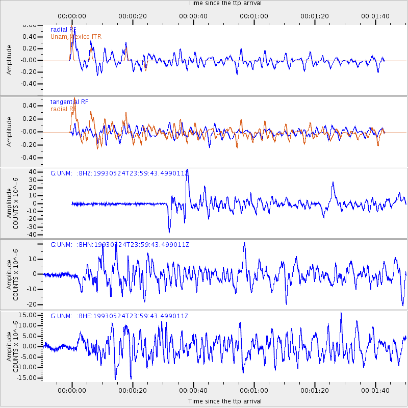
Signal To Noise
| Channel | StoN | STA | LTA |
| G:UNM: :BHN:19930524T23:59:43.499011Z | 5.1014466 | 4.238495E-6 | 8.308418E-7 |
| G:UNM: :BHE:19930524T23:59:43.499011Z | 3.3977258 | 3.029783E-6 | 8.917092E-7 |
| G:UNM: :BHZ:19930524T23:59:43.499011Z | 19.492067 | 1.2436486E-5 | 6.380281E-7 |
| Arrivals |
| Ps | 6.5 SECOND |
| PpPs | 18 SECOND |
| PsPs/PpSs | 24 SECOND |


