You are here: Home > Network List > G - GEOSCOPE Stations List
> Station UNM Unam,Mexico > Earthquake Result Viewer
UNM Unam,Mexico - Earthquake Result Viewer
| Earthquake location: |
Jujuy Province, Argentina |
| Earthquake latitude/longitude: |
-22.6/-66.5 |
| Earthquake time(UTC): |
1993/05/24 (144) 23:51:30 GMT |
| Earthquake Depth: |
238 km |
| Earthquake Magnitude: |
6.6 MB |
| Earthquake Catalog/Contributor: |
WHDF/NEIC |
|
| Network: |
G GEOSCOPE |
| Station: |
UNM Unam,Mexico |
| Lat/Lon: |
19.33 N/99.18 W |
| Elevation: |
2280 m |
|
| Distance: |
52.5 deg |
| Az: |
320.062 deg |
| Baz: |
141.09 deg |
| Ray Param: |
0.0658458 |
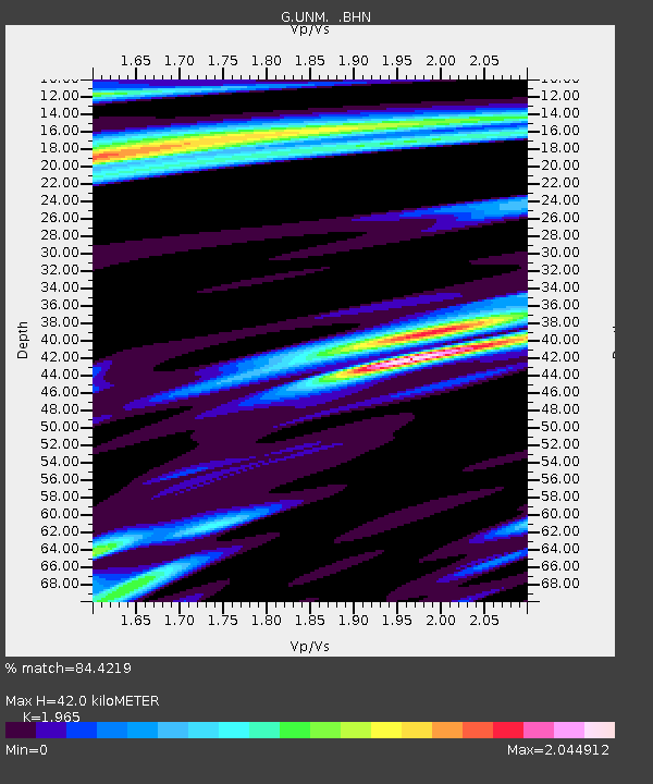
| Estimated Moho Depth: |
42.0 km |
| Estimated Crust Vp/Vs: |
1.97 |
| Assumed Crust Vp: |
6.597 km/s |
| Estimated Crust Vs: |
3.358 km/s |
| Estimated Crust Poisson's Ratio: |
0.33 |
|
| Radial Match: |
84.4219 % |
| Radial Bump: |
400 |
| Transverse Match: |
75.963455 % |
| Transverse Bump: |
400 |
| SOD ConfigId: |
16938 |
| Insert Time: |
2010-02-27 00:37:49.335 +0000 |
| GWidth: |
2.5 |
| Max Bumps: |
400 |
| Tol: |
0.001 |
|

Signal To Noise
| Channel | StoN | STA | LTA |
| G:UNM: :BHN:19930524T23:59:48.150012Z | 6.934949 | 5.6022277E-6 | 8.0782536E-7 |
| G:UNM: :BHE:19930524T23:59:48.150012Z | 2.9228888 | 2.6645428E-6 | 9.116128E-7 |
| G:UNM: :BHZ:19930524T23:59:48.150012Z | 29.296305 | 1.7253691E-5 | 5.8893744E-7 |
| Arrivals |
| Ps | 6.5 SECOND |
| PpPs | 18 SECOND |
| PsPs/PpSs | 24 SECOND |


