You are here: Home > Network List > G - GEOSCOPE Stations List
> Station UNM Unam,Mexico > Earthquake Result Viewer
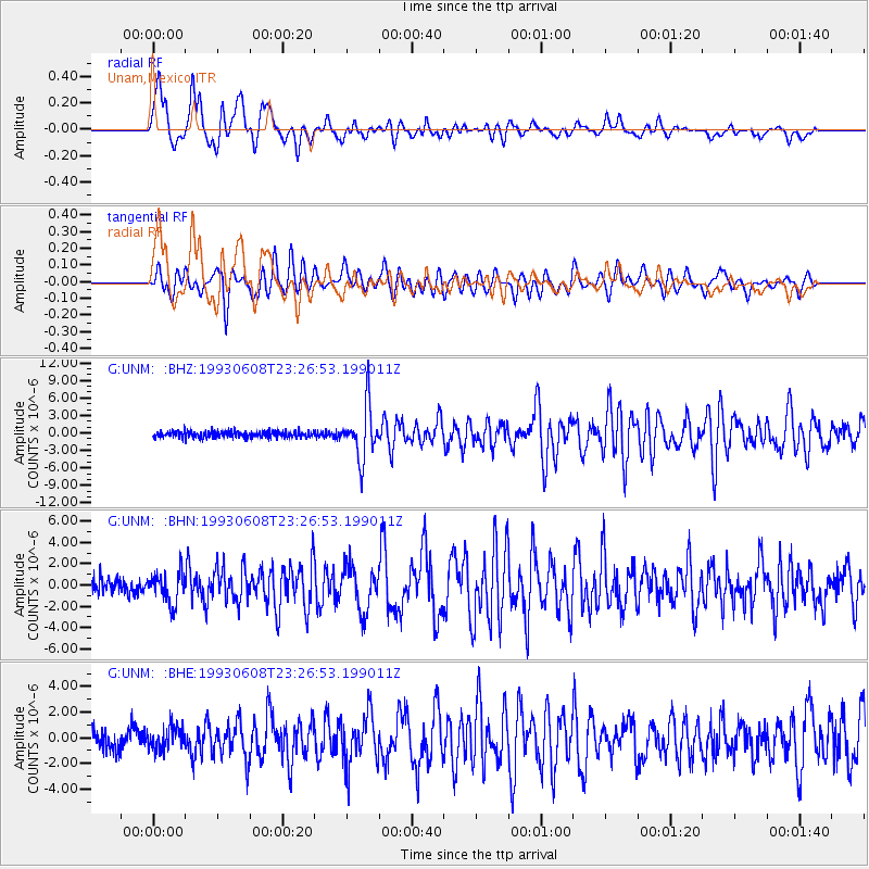
UNM Unam,Mexico - Earthquake Result Viewer

| Earthquake location: |
San Juan Province, Argentina |
| Earthquake latitude/longitude: |
-31.6/-69.2 |
| Earthquake time(UTC): |
1993/06/08 (159) 23:17:41 GMT |
| Earthquake Depth: |
113 km |
| Earthquake Magnitude: |
6.4 MB, 6.4 UNKNOWN |
| Earthquake Catalog/Contributor: |
WHDF/NEIC |
|
| Network: |
G GEOSCOPE |
| Station: |
UNM Unam,Mexico |
| Lat/Lon: |
19.33 N/99.18 W |
| Elevation: |
2280 m |
|
| Distance: |
58.2 deg |
| Az: |
326.311 deg |
| Baz: |
149.918 deg |
| Ray Param: |
0.06264885 |
| Estimated Moho Depth: |
43.0 km |
| Estimated Crust Vp/Vs: |
1.91 |
| Assumed Crust Vp: |
6.597 km/s |
| Estimated Crust Vs: |
3.445 km/s |
| Estimated Crust Poisson's Ratio: |
0.31 |
|
| Radial Match: |
89.93712 % |
| Radial Bump: |
400 |
| Transverse Match: |
81.142166 % |
| Transverse Bump: |
400 |
| SOD ConfigId: |
16938 |
| Insert Time: |
2010-02-27 00:37:50.628 +0000 |
| GWidth: |
2.5 |
| Max Bumps: |
400 |
| Tol: |
0.001 |
|
Signal To Noise
| Channel | StoN | STA | LTA |
| G:UNM: :BHN:19930608T23:26:53.199011Z | 2.0751708 | 1.4713144E-6 | 7.090089E-7 |
| G:UNM: :BHE:19930608T23:26:53.199011Z | 1.1998575 | 8.8255473E-7 | 7.3554963E-7 |
| G:UNM: :BHZ:19930608T23:26:53.199011Z | 7.9815063 | 4.3964883E-6 | 5.508344E-7 |
| Arrivals |
| Ps | 6.3 SECOND |
| PpPs | 18 SECOND |
| PsPs/PpSs | 24 SECOND |


