You are here: Home > Network List > UW - Pacific Northwest Regional Seismic Network Stations List
> Station MRBL Marblemount, WA, USA > Earthquake Result Viewer
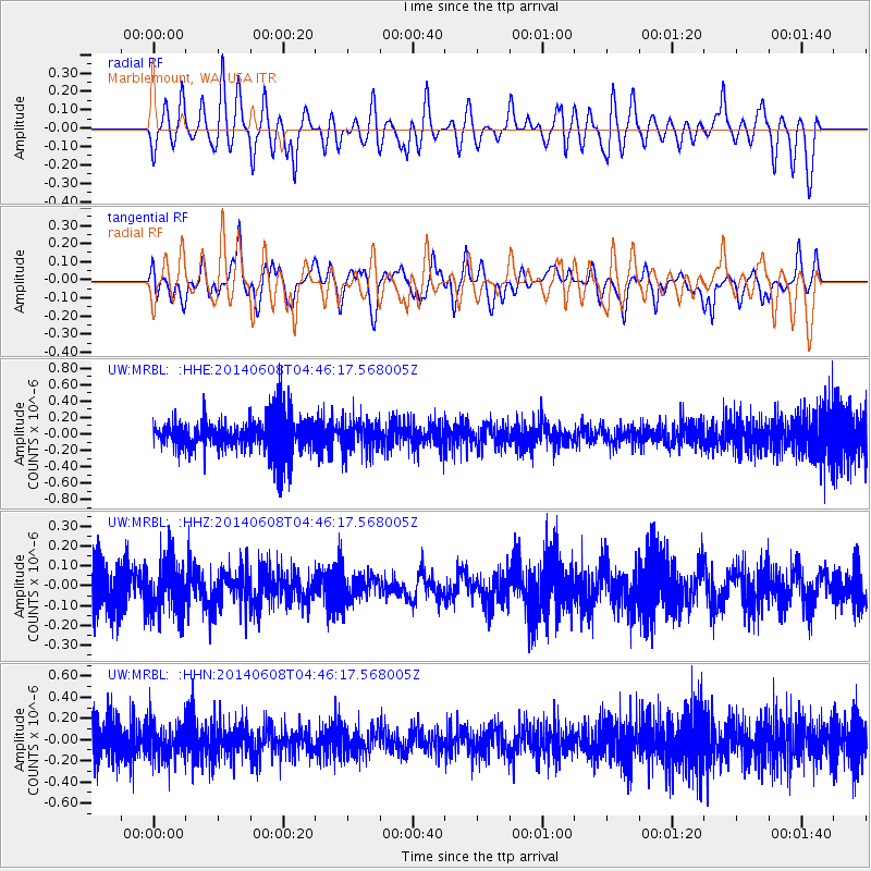
MRBL Marblemount, WA, USA - Earthquake Result Viewer
*The percent match for this event was below the threshold and hence no stack was calculated.
| Earthquake location: |
Mindoro, Philippines |
| Earthquake latitude/longitude: |
13.2/120.2 |
| Earthquake time(UTC): |
2014/06/08 (159) 04:33:13 GMT |
| Earthquake Depth: |
11 km |
| Earthquake Magnitude: |
4.7 mb |
| Earthquake Catalog/Contributor: |
ISC/ISC |
|
| Network: |
UW Pacific Northwest Regional Seismic Network |
| Station: |
MRBL Marblemount, WA, USA |
| Lat/Lon: |
48.52 N/121.48 W |
| Elevation: |
75 m |
|
| Distance: |
97.9 deg |
| Az: |
36.23 deg |
| Baz: |
300.041 deg |
| Ray Param: |
$rayparam |
*The percent match for this event was below the threshold and hence was not used in the summary stack. |
|
| Radial Match: |
58.740505 % |
| Radial Bump: |
400 |
| Transverse Match: |
55.627167 % |
| Transverse Bump: |
400 |
| SOD ConfigId: |
3390531 |
| Insert Time: |
2019-04-12 05:15:07.930 +0000 |
| GWidth: |
2.5 |
| Max Bumps: |
400 |
| Tol: |
0.001 |
|
Signal To Noise
| Channel | StoN | STA | LTA |
| UW:MRBL: :HHZ:20140608T04:46:17.568005Z | 1.1336639 | 1.2711736E-7 | 1.1212967E-7 |
| UW:MRBL: :HHN:20140608T04:46:17.568005Z | 0.94538194 | 1.5932385E-7 | 1.6852856E-7 |
| UW:MRBL: :HHE:20140608T04:46:17.568005Z | 0.8951578 | 1.8572425E-7 | 2.0747653E-7 |
| Arrivals |
| Ps | |
| PpPs | |
| PsPs/PpSs | |


