You are here: Home > Network List > G - GEOSCOPE Stations List
> Station UNM Unam,Mexico > Earthquake Result Viewer
UNM Unam,Mexico - Earthquake Result Viewer
| Earthquake location: |
Western Brazil |
| Earthquake latitude/longitude: |
-8.5/-71.5 |
| Earthquake time(UTC): |
1993/05/06 (126) 13:03:19 GMT |
| Earthquake Depth: |
586 km |
| Earthquake Magnitude: |
5.8 MB, 5.8 UNKNOWN |
| Earthquake Catalog/Contributor: |
WHDF/NEIC |
|
| Network: |
G GEOSCOPE |
| Station: |
UNM Unam,Mexico |
| Lat/Lon: |
19.33 N/99.18 W |
| Elevation: |
2280 m |
|
| Distance: |
38.8 deg |
| Az: |
315.585 deg |
| Baz: |
132.85 deg |
| Ray Param: |
0.07231662 |
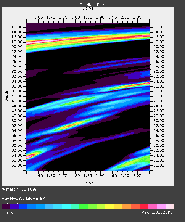
| Estimated Moho Depth: |
18.0 km |
| Estimated Crust Vp/Vs: |
1.63 |
| Assumed Crust Vp: |
6.597 km/s |
| Estimated Crust Vs: |
4.048 km/s |
| Estimated Crust Poisson's Ratio: |
0.20 |
|
| Radial Match: |
80.18997 % |
| Radial Bump: |
400 |
| Transverse Match: |
66.32174 % |
| Transverse Bump: |
400 |
| SOD ConfigId: |
17000 |
| Insert Time: |
2010-02-27 00:37:52.002 +0000 |
| GWidth: |
2.5 |
| Max Bumps: |
400 |
| Tol: |
0.001 |
|

Signal To Noise
| Channel | StoN | STA | LTA |
| G:UNM: :BHN:19930506T13:09:24.599011Z | 2.0237772 | 1.5367517E-6 | 7.5934827E-7 |
| G:UNM: :BHE:19930506T13:09:24.599011Z | 2.132783 | 1.2422735E-6 | 5.82466E-7 |
| G:UNM: :BHZ:19930506T13:09:24.599011Z | 7.235824 | 4.3794453E-6 | 6.0524485E-7 |
| Arrivals |
| Ps | 1.9 SECOND |
| PpPs | 6.7 SECOND |
| PsPs/PpSs | 8.5 SECOND |


