You are here: Home > Network List > TA - USArray Transportable Network (new EarthScope stations) Stations List
> Station H35A Sunnyside Ranch, Fairfax, MN, USA > Earthquake Result Viewer
H35A Sunnyside Ranch, Fairfax, MN, USA - Earthquake Result Viewer
| Earthquake location: |
Off Coast Of Central America |
| Earthquake latitude/longitude: |
12.5/-88.7 |
| Earthquake time(UTC): |
2012/08/28 (241) 06:08:16 GMT |
| Earthquake Depth: |
35 km |
| Earthquake Magnitude: |
5.5 MW, 5.0 MS, 5.1 MB, 5.5 MW |
| Earthquake Catalog/Contributor: |
WHDF/NEIC |
|
| Network: |
TA USArray Transportable Network (new EarthScope stations) |
| Station: |
H35A Sunnyside Ranch, Fairfax, MN, USA |
| Lat/Lon: |
44.70 N/94.83 W |
| Elevation: |
345 m |
|
| Distance: |
32.6 deg |
| Az: |
351.803 deg |
| Baz: |
168.739 deg |
| Ray Param: |
0.0785449 |
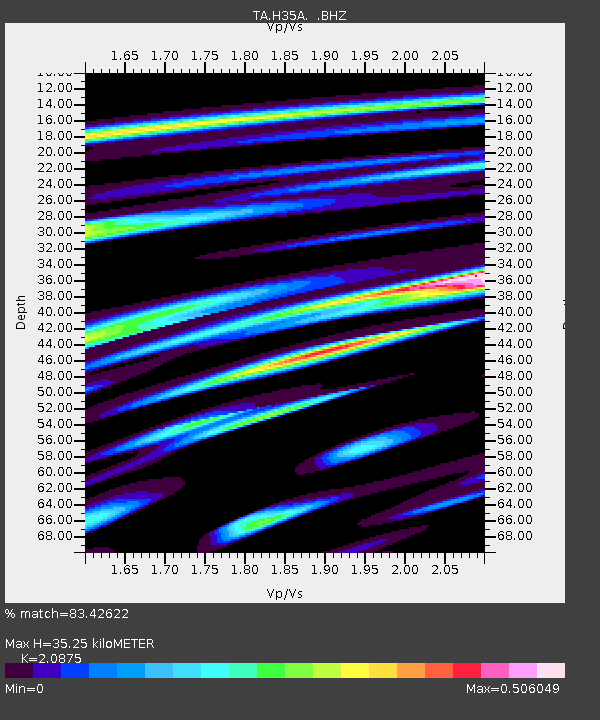
| Estimated Moho Depth: |
35.25 km |
| Estimated Crust Vp/Vs: |
2.09 |
| Assumed Crust Vp: |
6.571 km/s |
| Estimated Crust Vs: |
3.148 km/s |
| Estimated Crust Poisson's Ratio: |
0.35 |
|
| Radial Match: |
83.42622 % |
| Radial Bump: |
272 |
| Transverse Match: |
56.87767 % |
| Transverse Bump: |
400 |
| SOD ConfigId: |
469095 |
| Insert Time: |
2013-02-22 08:52:57.137 +0000 |
| GWidth: |
2.5 |
| Max Bumps: |
400 |
| Tol: |
0.001 |
|
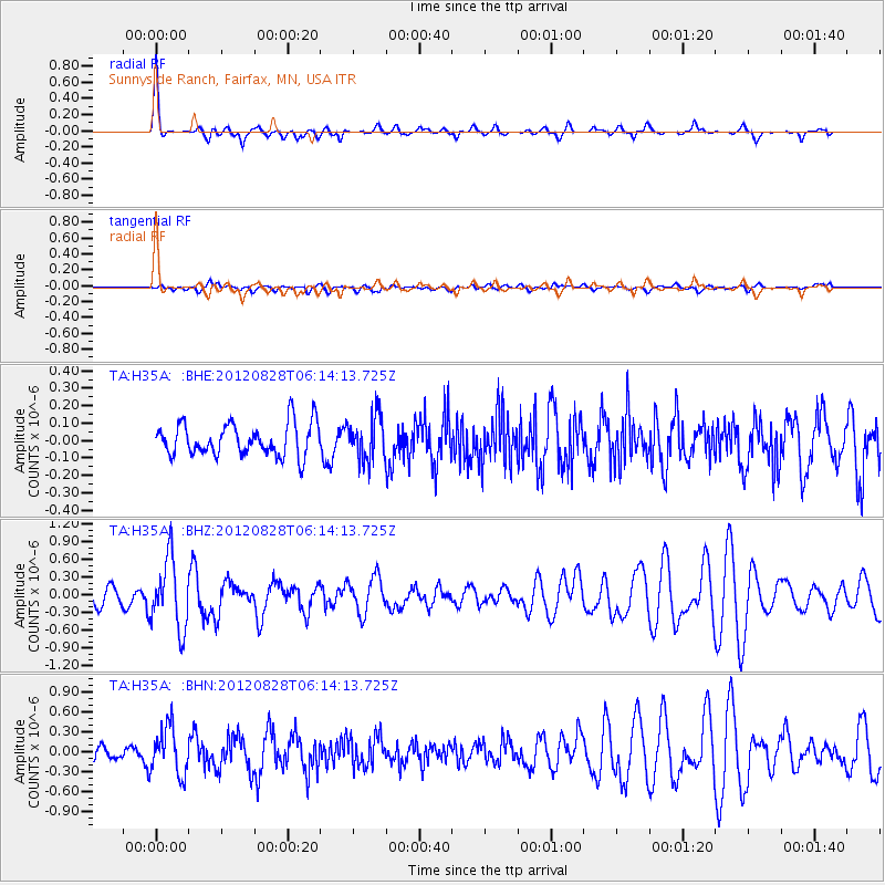
Signal To Noise
| Channel | StoN | STA | LTA |
| TA:H35A: :BHZ:20120828T06:14:13.725Z | 4.579724 | 5.8849116E-7 | 1.2849927E-7 |
| TA:H35A: :BHN:20120828T06:14:13.725Z | 4.0946217 | 3.5747408E-7 | 8.730331E-8 |
| TA:H35A: :BHE:20120828T06:14:13.725Z | 1.3335575 | 1.241481E-7 | 9.309542E-8 |
| Arrivals |
| Ps | 6.3 SECOND |
| PpPs | 15 SECOND |
| PsPs/PpSs | 22 SECOND |


