You are here: Home > Network List > TA - USArray Transportable Network (new EarthScope stations) Stations List
> Station I38A Scanlan Farm, Eyota, MN, USA > Earthquake Result Viewer
I38A Scanlan Farm, Eyota, MN, USA - Earthquake Result Viewer
| Earthquake location: |
Off Coast Of Central America |
| Earthquake latitude/longitude: |
12.5/-88.7 |
| Earthquake time(UTC): |
2012/08/28 (241) 06:08:16 GMT |
| Earthquake Depth: |
35 km |
| Earthquake Magnitude: |
5.5 MW, 5.0 MS, 5.1 MB, 5.5 MW |
| Earthquake Catalog/Contributor: |
WHDF/NEIC |
|
| Network: |
TA USArray Transportable Network (new EarthScope stations) |
| Station: |
I38A Scanlan Farm, Eyota, MN, USA |
| Lat/Lon: |
44.04 N/92.33 W |
| Elevation: |
390 m |
|
| Distance: |
31.6 deg |
| Az: |
354.941 deg |
| Baz: |
173.141 deg |
| Ray Param: |
0.07894099 |
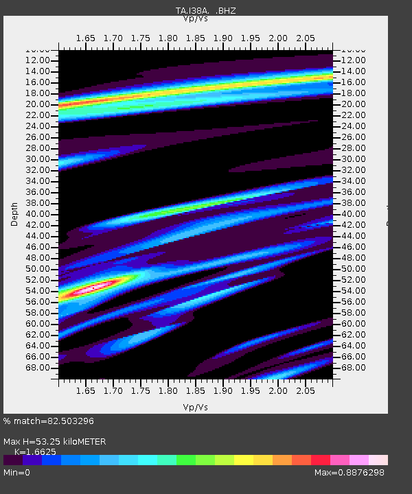
| Estimated Moho Depth: |
53.25 km |
| Estimated Crust Vp/Vs: |
1.66 |
| Assumed Crust Vp: |
6.571 km/s |
| Estimated Crust Vs: |
3.952 km/s |
| Estimated Crust Poisson's Ratio: |
0.22 |
|
| Radial Match: |
82.503296 % |
| Radial Bump: |
294 |
| Transverse Match: |
69.50868 % |
| Transverse Bump: |
400 |
| SOD ConfigId: |
469095 |
| Insert Time: |
2013-02-22 08:53:18.355 +0000 |
| GWidth: |
2.5 |
| Max Bumps: |
400 |
| Tol: |
0.001 |
|
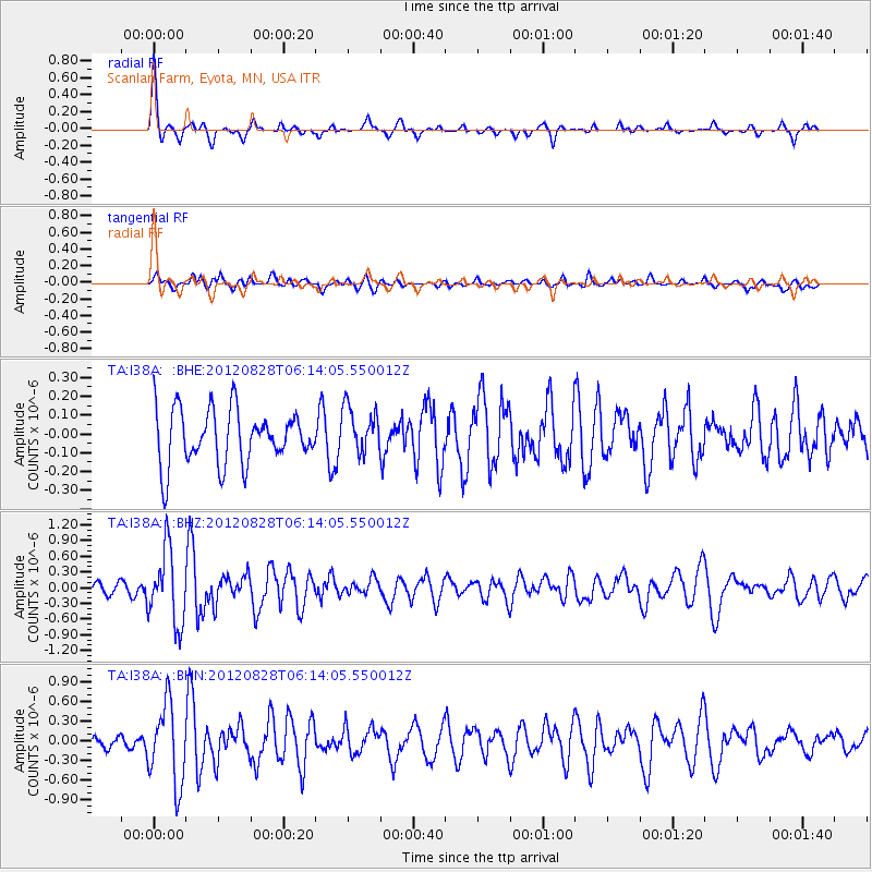
Signal To Noise
| Channel | StoN | STA | LTA |
| TA:I38A: :BHZ:20120828T06:14:05.550012Z | 4.3129144 | 7.038402E-7 | 1.6319365E-7 |
| TA:I38A: :BHN:20120828T06:14:05.550012Z | 7.750009 | 6.147273E-7 | 7.931956E-8 |
| TA:I38A: :BHE:20120828T06:14:05.550012Z | 0.8706687 | 1.2504287E-7 | 1.4361706E-7 |
| Arrivals |
| Ps | 5.9 SECOND |
| PpPs | 20 SECOND |
| PsPs/PpSs | 26 SECOND |


