You are here: Home > Network List > TA - USArray Transportable Network (new EarthScope stations) Stations List
> Station K37A Belmond, IA, USA > Earthquake Result Viewer
K37A Belmond, IA, USA - Earthquake Result Viewer
| Earthquake location: |
Off Coast Of Central America |
| Earthquake latitude/longitude: |
12.5/-88.7 |
| Earthquake time(UTC): |
2012/08/28 (241) 06:08:16 GMT |
| Earthquake Depth: |
35 km |
| Earthquake Magnitude: |
5.5 MW, 5.0 MS, 5.1 MB, 5.5 MW |
| Earthquake Catalog/Contributor: |
WHDF/NEIC |
|
| Network: |
TA USArray Transportable Network (new EarthScope stations) |
| Station: |
K37A Belmond, IA, USA |
| Lat/Lon: |
42.77 N/93.64 W |
| Elevation: |
365 m |
|
| Distance: |
30.5 deg |
| Az: |
352.759 deg |
| Baz: |
170.375 deg |
| Ray Param: |
0.07928027 |
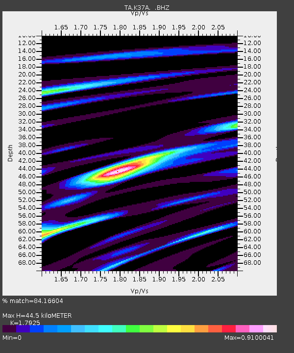
| Estimated Moho Depth: |
44.5 km |
| Estimated Crust Vp/Vs: |
1.79 |
| Assumed Crust Vp: |
6.53 km/s |
| Estimated Crust Vs: |
3.643 km/s |
| Estimated Crust Poisson's Ratio: |
0.27 |
|
| Radial Match: |
84.16604 % |
| Radial Bump: |
296 |
| Transverse Match: |
68.536064 % |
| Transverse Bump: |
400 |
| SOD ConfigId: |
469095 |
| Insert Time: |
2013-02-22 08:53:40.289 +0000 |
| GWidth: |
2.5 |
| Max Bumps: |
400 |
| Tol: |
0.001 |
|

Signal To Noise
| Channel | StoN | STA | LTA |
| TA:K37A: :BHZ:20120828T06:13:55.675012Z | 4.9691663 | 5.5000766E-7 | 1.1068409E-7 |
| TA:K37A: :BHN:20120828T06:13:55.675012Z | 5.824938 | 5.8047647E-7 | 9.965367E-8 |
| TA:K37A: :BHE:20120828T06:13:55.675012Z | 2.0165973 | 1.6209023E-7 | 8.037809E-8 |
| Arrivals |
| Ps | 5.9 SECOND |
| PpPs | 18 SECOND |
| PsPs/PpSs | 23 SECOND |


