You are here: Home > Network List > TA - USArray Transportable Network (new EarthScope stations) Stations List
> Station F41A Wisconsin Rapids, WI, USA > Earthquake Result Viewer
F41A Wisconsin Rapids, WI, USA - Earthquake Result Viewer

| Earthquake location: |
Off Coast Of Central America |
| Earthquake latitude/longitude: |
12.5/-88.7 |
| Earthquake time(UTC): |
2012/08/28 (241) 06:08:16 GMT |
| Earthquake Depth: |
35 km |
| Earthquake Magnitude: |
5.5 MW, 5.0 MS, 5.1 MB, 5.5 MW |
| Earthquake Catalog/Contributor: |
WHDF/NEIC |
|
| Network: |
TA USArray Transportable Network (new EarthScope stations) |
| Station: |
F41A Wisconsin Rapids, WI, USA |
| Lat/Lon: |
45.74 N/89.10 W |
| Elevation: |
509 m |
|
| Distance: |
33.2 deg |
| Az: |
359.423 deg |
| Baz: |
179.196 deg |
| Ray Param: |
0.07827203 |
| Estimated Moho Depth: |
64.25 km |
| Estimated Crust Vp/Vs: |
1.60 |
| Assumed Crust Vp: |
6.41 km/s |
| Estimated Crust Vs: |
4.006 km/s |
| Estimated Crust Poisson's Ratio: |
0.18 |
|
| Radial Match: |
80.06116 % |
| Radial Bump: |
236 |
| Transverse Match: |
54.64543 % |
| Transverse Bump: |
366 |
| SOD ConfigId: |
469095 |
| Insert Time: |
2013-02-22 08:55:47.888 +0000 |
| GWidth: |
2.5 |
| Max Bumps: |
400 |
| Tol: |
0.001 |
|
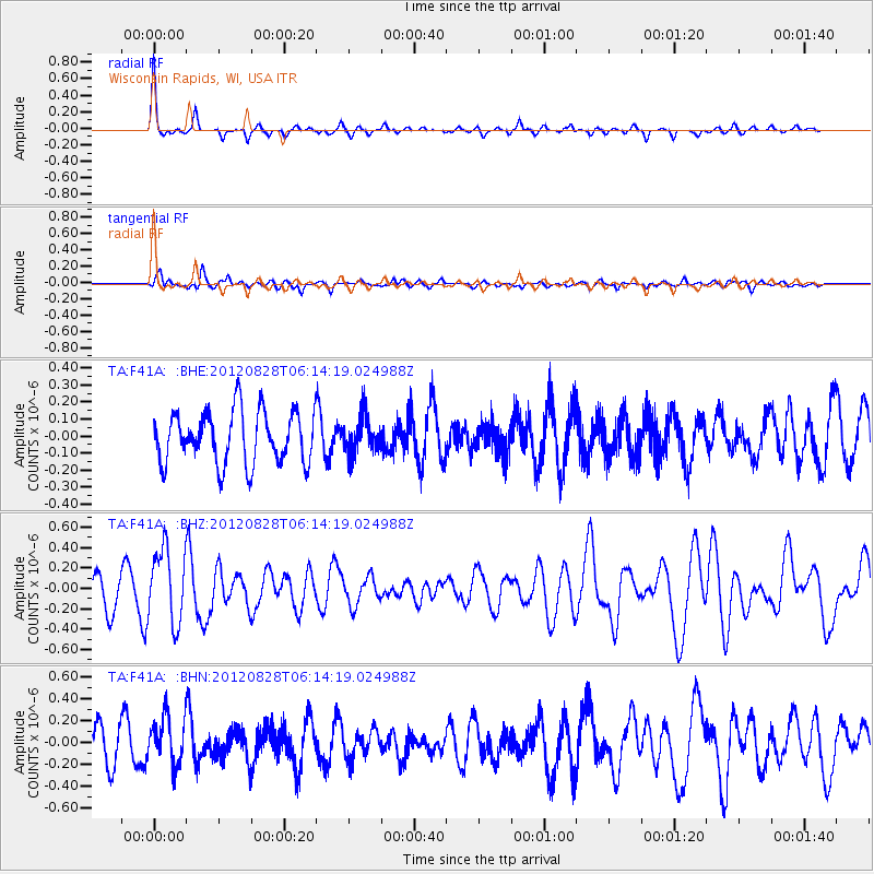
Signal To Noise
| Channel | StoN | STA | LTA |
| TA:F41A: :BHZ:20120828T06:14:19.024988Z | 2.0604393 | 3.6223557E-7 | 1.75805E-7 |
| TA:F41A: :BHN:20120828T06:14:19.024988Z | 1.669578 | 2.1827078E-7 | 1.3073411E-7 |
| TA:F41A: :BHE:20120828T06:14:19.024988Z | 0.699411 | 1.0704425E-7 | 1.5304914E-7 |
| Arrivals |
| Ps | 6.6 SECOND |
| PpPs | 24 SECOND |
| PsPs/PpSs | 30 SECOND |


