You are here: Home > Network List > UW - Pacific Northwest Regional Seismic Network Stations List
> Station UMAT Pilot Rock, OR, USA > Earthquake Result Viewer
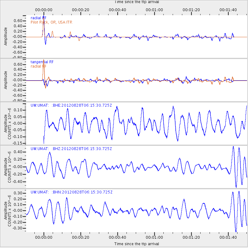
UMAT Pilot Rock, OR, USA - Earthquake Result Viewer
*The percent match for this event was below the threshold and hence no stack was calculated.
| Earthquake location: |
Off Coast Of Central America |
| Earthquake latitude/longitude: |
12.5/-88.7 |
| Earthquake time(UTC): |
2012/08/28 (241) 06:08:16 GMT |
| Earthquake Depth: |
35 km |
| Earthquake Magnitude: |
5.5 MW, 5.0 MS, 5.1 MB, 5.5 MW |
| Earthquake Catalog/Contributor: |
WHDF/NEIC |
|
| Network: |
UW Pacific Northwest Regional Seismic Network |
| Station: |
UMAT Pilot Rock, OR, USA |
| Lat/Lon: |
45.29 N/118.96 W |
| Elevation: |
1318 m |
|
| Distance: |
41.7 deg |
| Az: |
327.597 deg |
| Baz: |
132.141 deg |
| Ray Param: |
$rayparam |
*The percent match for this event was below the threshold and hence was not used in the summary stack. |
|
| Radial Match: |
78.12572 % |
| Radial Bump: |
227 |
| Transverse Match: |
45.41357 % |
| Transverse Bump: |
315 |
| SOD ConfigId: |
469095 |
| Insert Time: |
2013-02-22 08:58:23.914 +0000 |
| GWidth: |
2.5 |
| Max Bumps: |
400 |
| Tol: |
0.001 |
|
Signal To Noise
| Channel | StoN | STA | LTA |
| UW:UMAT: :BHZ:20120828T06:15:30.725Z | 3.196784 | 2.1179424E-7 | 6.6252284E-8 |
| UW:UMAT: :BHN:20120828T06:15:30.725Z | 1.756149 | 1.1240182E-7 | 6.4004716E-8 |
| UW:UMAT: :BHE:20120828T06:15:30.725Z | 1.0326757 | 5.3521276E-8 | 5.1827765E-8 |
| Arrivals |
| Ps | |
| PpPs | |
| PsPs/PpSs | |


