You are here: Home > Network List > G - GEOSCOPE Stations List
> Station UNM Unam,Mexico > Earthquake Result Viewer
UNM Unam,Mexico - Earthquake Result Viewer
| Earthquake location: |
Near Coast Of Central Chile |
| Earthquake latitude/longitude: |
-31.9/-71.6 |
| Earthquake time(UTC): |
1996/09/09 (253) 00:20:39 GMT |
| Earthquake Depth: |
39 km |
| Earthquake Magnitude: |
6.0 MB, 5.5 MS, 6.0 UNKNOWN, 5.8 ME |
| Earthquake Catalog/Contributor: |
WHDF/NEIC |
|
| Network: |
G GEOSCOPE |
| Station: |
UNM Unam,Mexico |
| Lat/Lon: |
19.33 N/99.18 W |
| Elevation: |
2280 m |
|
| Distance: |
57.4 deg |
| Az: |
328.695 deg |
| Baz: |
152.096 deg |
| Ray Param: |
0.063434295 |
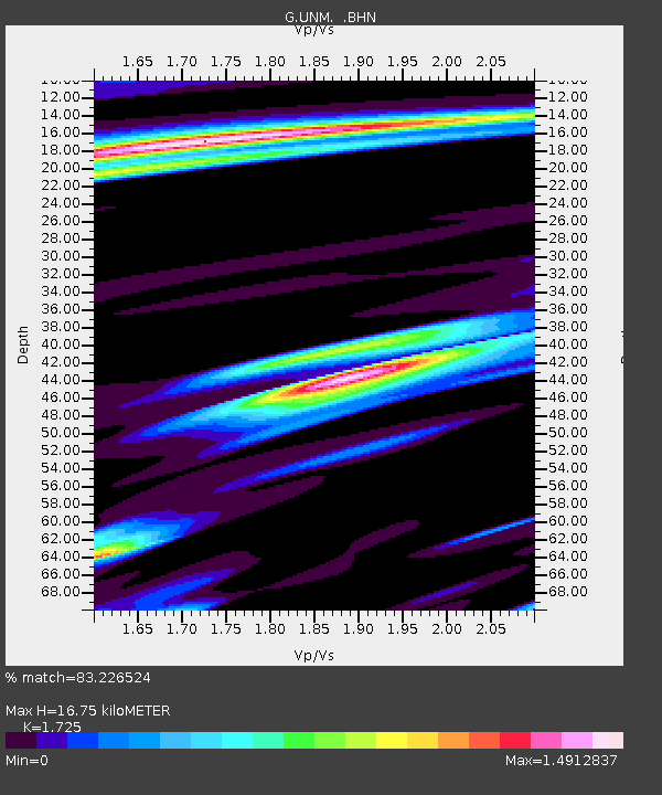
| Estimated Moho Depth: |
16.75 km |
| Estimated Crust Vp/Vs: |
1.73 |
| Assumed Crust Vp: |
6.597 km/s |
| Estimated Crust Vs: |
3.825 km/s |
| Estimated Crust Poisson's Ratio: |
0.25 |
|
| Radial Match: |
83.226524 % |
| Radial Bump: |
400 |
| Transverse Match: |
81.10552 % |
| Transverse Bump: |
400 |
| SOD ConfigId: |
6273 |
| Insert Time: |
2010-02-27 00:38:17.836 +0000 |
| GWidth: |
2.5 |
| Max Bumps: |
400 |
| Tol: |
0.001 |
|

Signal To Noise
| Channel | StoN | STA | LTA |
| G:UNM: :BHN:19960909T00:29:53.050012Z | 1.2020761 | 6.0150836E-7 | 5.0039125E-7 |
| G:UNM: :BHE:19960909T00:29:53.050012Z | 1.8400269 | 6.83096E-7 | 3.7124238E-7 |
| G:UNM: :BHZ:19960909T00:29:53.050012Z | 4.39658 | 1.7311164E-6 | 3.9374157E-7 |
| Arrivals |
| Ps | 1.9 SECOND |
| PpPs | 6.6 SECOND |
| PsPs/PpSs | 8.5 SECOND |


