You are here: Home > Network List > G - GEOSCOPE Stations List
> Station UNM Unam,Mexico > Earthquake Result Viewer
UNM Unam,Mexico - Earthquake Result Viewer
| Earthquake location: |
Near Coast Of Northern Chile |
| Earthquake latitude/longitude: |
-23.9/-70.1 |
| Earthquake time(UTC): |
1996/04/19 (110) 00:19:31 GMT |
| Earthquake Depth: |
50 km |
| Earthquake Magnitude: |
6.0 MB, 6.1 MS, 6.6 UNKNOWN, 6.5 ME |
| Earthquake Catalog/Contributor: |
WHDF/NEIC |
|
| Network: |
G GEOSCOPE |
| Station: |
UNM Unam,Mexico |
| Lat/Lon: |
19.33 N/99.18 W |
| Elevation: |
2280 m |
|
| Distance: |
51.5 deg |
| Az: |
324.097 deg |
| Baz: |
145.377 deg |
| Ray Param: |
0.06723564 |
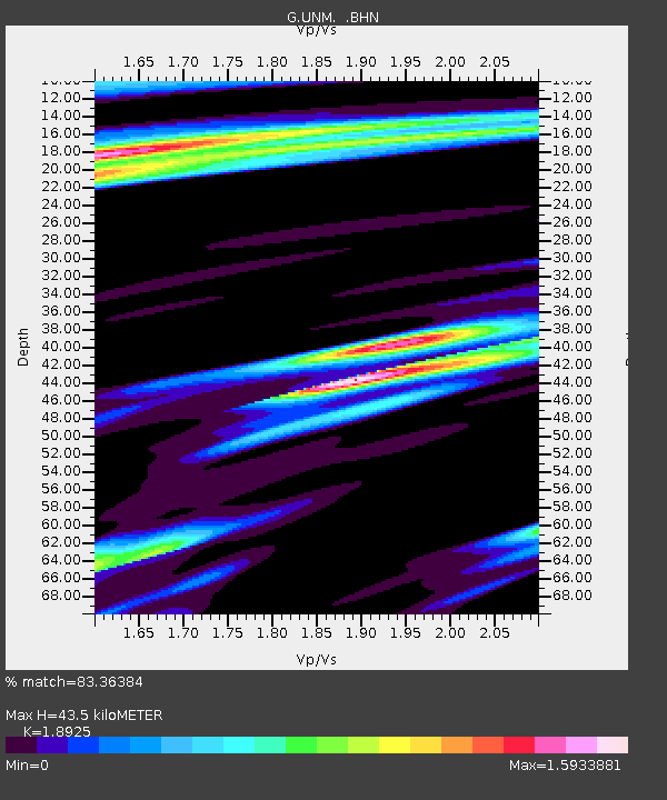
| Estimated Moho Depth: |
43.5 km |
| Estimated Crust Vp/Vs: |
1.89 |
| Assumed Crust Vp: |
6.597 km/s |
| Estimated Crust Vs: |
3.486 km/s |
| Estimated Crust Poisson's Ratio: |
0.31 |
|
| Radial Match: |
83.36384 % |
| Radial Bump: |
388 |
| Transverse Match: |
70.94036 % |
| Transverse Bump: |
400 |
| SOD ConfigId: |
6273 |
| Insert Time: |
2010-02-27 00:38:27.488 +0000 |
| GWidth: |
2.5 |
| Max Bumps: |
400 |
| Tol: |
0.001 |
|

Signal To Noise
| Channel | StoN | STA | LTA |
| G:UNM: :BHN:19960419T00:28:01.248987Z | 0.81761086 | 8.287128E-7 | 1.0135785E-6 |
| G:UNM: :BHE:19960419T00:28:01.248987Z | 1.012726 | 7.934907E-7 | 7.835196E-7 |
| G:UNM: :BHZ:19960419T00:28:01.248987Z | 3.2329943 | 1.9095169E-6 | 5.9063416E-7 |
| Arrivals |
| Ps | 6.2 SECOND |
| PpPs | 18 SECOND |
| PsPs/PpSs | 24 SECOND |


