You are here: Home > Network List > G - GEOSCOPE Stations List
> Station UNM Unam,Mexico > Earthquake Result Viewer
UNM Unam,Mexico - Earthquake Result Viewer
| Earthquake location: |
Easter Island Region |
| Earthquake latitude/longitude: |
-22.1/-113.4 |
| Earthquake time(UTC): |
1996/09/05 (249) 08:14:14 GMT |
| Earthquake Depth: |
10 km |
| Earthquake Magnitude: |
6.2 MB, 7.0 MS, 7.0 UNKNOWN, 6.9 MW |
| Earthquake Catalog/Contributor: |
WHDF/NEIC |
|
| Network: |
G GEOSCOPE |
| Station: |
UNM Unam,Mexico |
| Lat/Lon: |
19.33 N/99.18 W |
| Elevation: |
2280 m |
|
| Distance: |
43.5 deg |
| Az: |
19.752 deg |
| Baz: |
199.381 deg |
| Ray Param: |
0.072520465 |
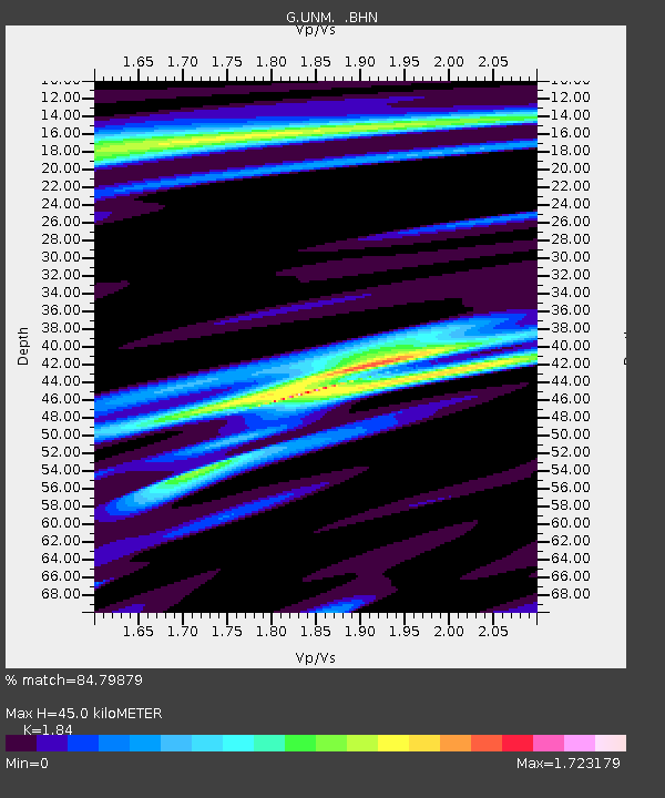
| Estimated Moho Depth: |
45.0 km |
| Estimated Crust Vp/Vs: |
1.84 |
| Assumed Crust Vp: |
6.597 km/s |
| Estimated Crust Vs: |
3.586 km/s |
| Estimated Crust Poisson's Ratio: |
0.29 |
|
| Radial Match: |
84.79879 % |
| Radial Bump: |
335 |
| Transverse Match: |
81.26318 % |
| Transverse Bump: |
364 |
| SOD ConfigId: |
6273 |
| Insert Time: |
2010-02-27 00:38:35.598 +0000 |
| GWidth: |
2.5 |
| Max Bumps: |
400 |
| Tol: |
0.001 |
|

Signal To Noise
| Channel | StoN | STA | LTA |
| G:UNM: :BHN:19960905T08:21:46.900Z | 2.9906511 | 1.284528E-6 | 4.295145E-7 |
| G:UNM: :BHE:19960905T08:21:46.900Z | 1.6238158 | 5.747842E-7 | 3.5397133E-7 |
| G:UNM: :BHZ:19960905T08:21:46.900Z | 7.2044125 | 2.6883206E-6 | 3.7314916E-7 |
| Arrivals |
| Ps | 6.1 SECOND |
| PpPs | 18 SECOND |
| PsPs/PpSs | 24 SECOND |


