You are here: Home > Network List > G - GEOSCOPE Stations List
> Station UNM Unam,Mexico > Earthquake Result Viewer
UNM Unam,Mexico - Earthquake Result Viewer
| Earthquake location: |
Jujuy Province, Argentina |
| Earthquake latitude/longitude: |
-23.0/-66.3 |
| Earthquake time(UTC): |
1997/07/20 (201) 10:14:22 GMT |
| Earthquake Depth: |
256 km |
| Earthquake Magnitude: |
5.7 MB, 6.1 UNKNOWN, 5.7 ME |
| Earthquake Catalog/Contributor: |
WHDF/NEIC |
|
| Network: |
G GEOSCOPE |
| Station: |
UNM Unam,Mexico |
| Lat/Lon: |
19.33 N/99.18 W |
| Elevation: |
2280 m |
|
| Distance: |
52.9 deg |
| Az: |
320.009 deg |
| Baz: |
141.158 deg |
| Ray Param: |
0.065509655 |
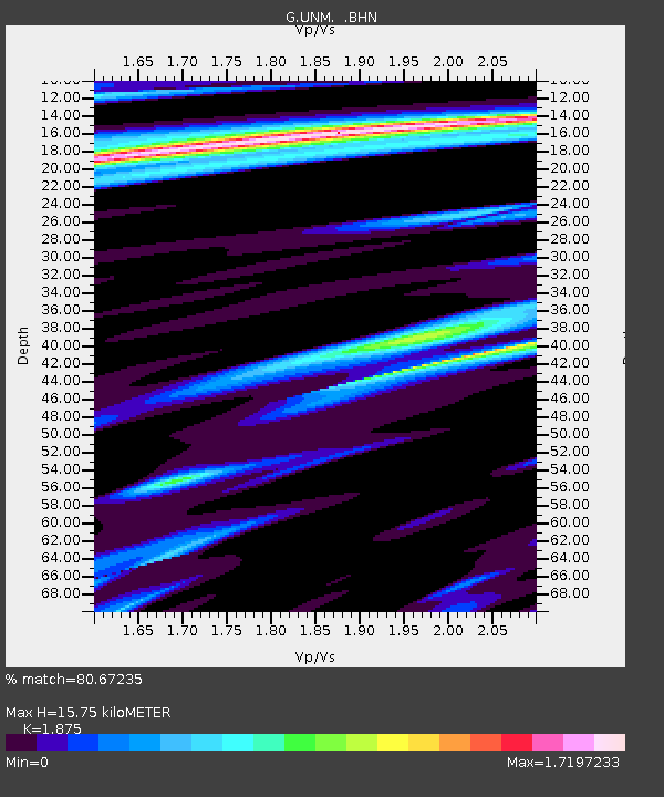
| Estimated Moho Depth: |
15.75 km |
| Estimated Crust Vp/Vs: |
1.88 |
| Assumed Crust Vp: |
6.597 km/s |
| Estimated Crust Vs: |
3.519 km/s |
| Estimated Crust Poisson's Ratio: |
0.30 |
|
| Radial Match: |
80.67235 % |
| Radial Bump: |
400 |
| Transverse Match: |
70.62691 % |
| Transverse Bump: |
400 |
| SOD ConfigId: |
6273 |
| Insert Time: |
2010-02-27 00:38:44.445 +0000 |
| GWidth: |
2.5 |
| Max Bumps: |
400 |
| Tol: |
0.001 |
|
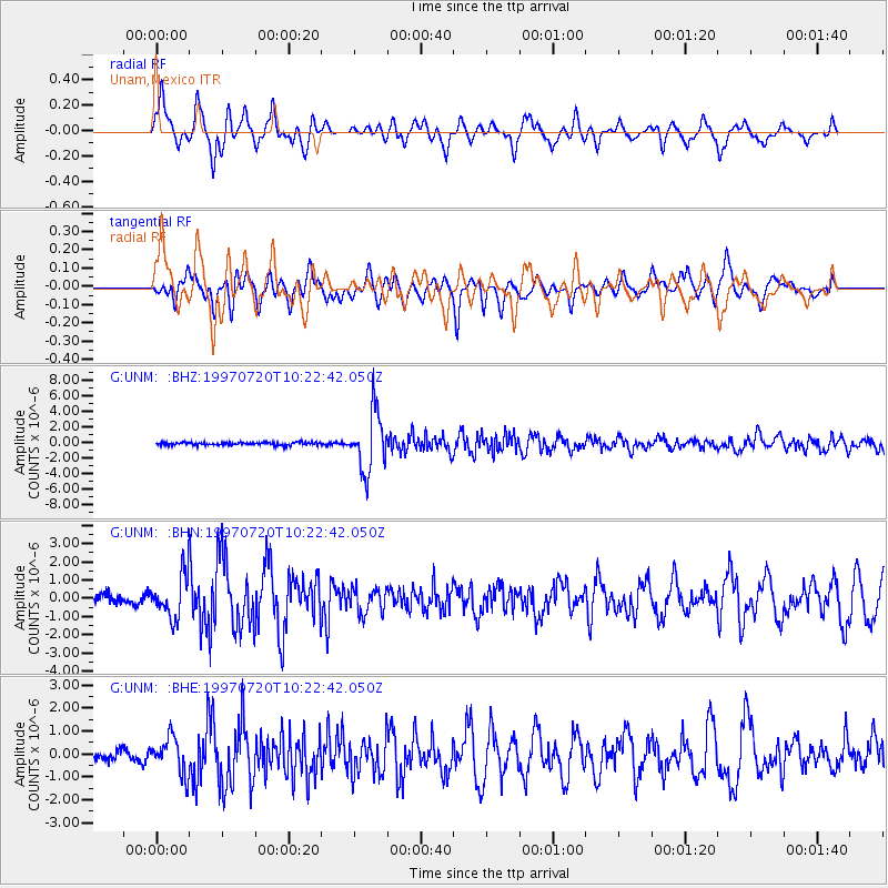
Signal To Noise
| Channel | StoN | STA | LTA |
| G:UNM: :BHN:19970720T10:22:42.050Z | 4.3819757 | 1.2062447E-6 | 2.7527418E-7 |
| G:UNM: :BHE:19970720T10:22:42.050Z | 3.5741725 | 8.0675864E-7 | 2.2571899E-7 |
| G:UNM: :BHZ:19970720T10:22:42.050Z | 20.8455 | 3.7625555E-6 | 1.8049725E-7 |
| Arrivals |
| Ps | 2.2 SECOND |
| PpPs | 6.5 SECOND |
| PsPs/PpSs | 8.7 SECOND |


