You are here: Home > Network List > TA - USArray Transportable Network (new EarthScope stations) Stations List
> Station O38A Galt, MO, USA > Earthquake Result Viewer
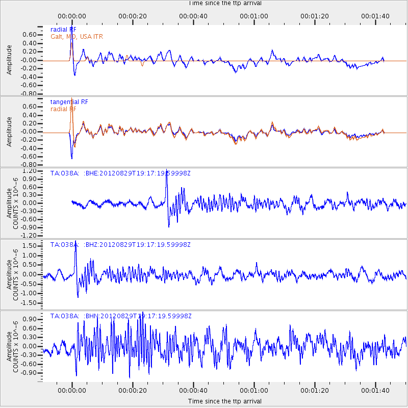
O38A Galt, MO, USA - Earthquake Result Viewer
*The percent match for this event was below the threshold and hence no stack was calculated.
| Earthquake location: |
Near East Coast Of Honshu, Japan |
| Earthquake latitude/longitude: |
38.4/141.8 |
| Earthquake time(UTC): |
2012/08/29 (242) 19:05:11 GMT |
| Earthquake Depth: |
47 km |
| Earthquake Magnitude: |
5.8 MB, 5.1 MS, 5.5 MW, 5.5 MW |
| Earthquake Catalog/Contributor: |
WHDF/NEIC |
|
| Network: |
TA USArray Transportable Network (new EarthScope stations) |
| Station: |
O38A Galt, MO, USA |
| Lat/Lon: |
40.12 N/93.47 W |
| Elevation: |
266 m |
|
| Distance: |
86.9 deg |
| Az: |
39.143 deg |
| Baz: |
319.714 deg |
| Ray Param: |
$rayparam |
*The percent match for this event was below the threshold and hence was not used in the summary stack. |
|
| Radial Match: |
70.95799 % |
| Radial Bump: |
400 |
| Transverse Match: |
74.047485 % |
| Transverse Bump: |
400 |
| SOD ConfigId: |
469095 |
| Insert Time: |
2013-02-22 09:19:37.001 +0000 |
| GWidth: |
2.5 |
| Max Bumps: |
400 |
| Tol: |
0.001 |
|
Signal To Noise
| Channel | StoN | STA | LTA |
| TA:O38A: :BHZ:20120829T19:17:19.59998Z | 6.0357485 | 6.2388773E-7 | 1.0336544E-7 |
| TA:O38A: :BHN:20120829T19:17:19.59998Z | 2.7560234 | 4.0573974E-7 | 1.4721925E-7 |
| TA:O38A: :BHE:20120829T19:17:19.59998Z | 6.0006266 | 4.5227728E-7 | 7.537168E-8 |
| Arrivals |
| Ps | |
| PpPs | |
| PsPs/PpSs | |


