You are here: Home > Network List > TA - USArray Transportable Network (new EarthScope stations) Stations List
> Station N36A Muff Farm, Clarinda, IA, USA > Earthquake Result Viewer
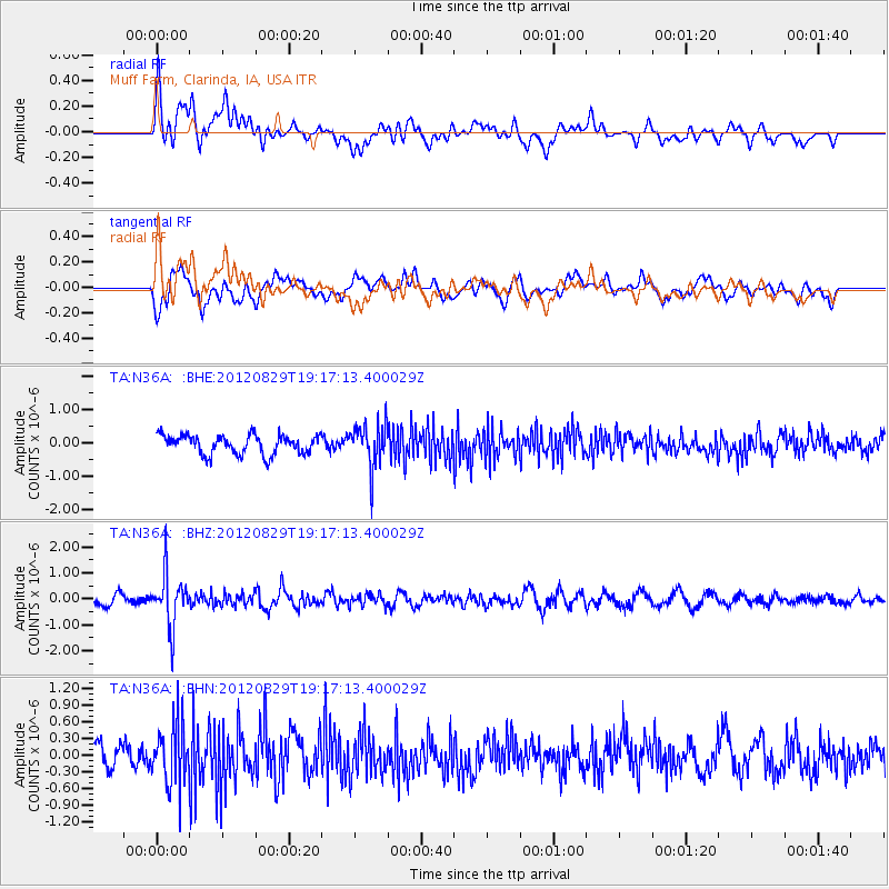
N36A Muff Farm, Clarinda, IA, USA - Earthquake Result Viewer
*The percent match for this event was below the threshold and hence no stack was calculated.
| Earthquake location: |
Near East Coast Of Honshu, Japan |
| Earthquake latitude/longitude: |
38.4/141.8 |
| Earthquake time(UTC): |
2012/08/29 (242) 19:05:11 GMT |
| Earthquake Depth: |
47 km |
| Earthquake Magnitude: |
5.8 MB, 5.1 MS, 5.5 MW, 5.5 MW |
| Earthquake Catalog/Contributor: |
WHDF/NEIC |
|
| Network: |
TA USArray Transportable Network (new EarthScope stations) |
| Station: |
N36A Muff Farm, Clarinda, IA, USA |
| Lat/Lon: |
40.82 N/94.96 W |
| Elevation: |
349 m |
|
| Distance: |
85.6 deg |
| Az: |
39.551 deg |
| Baz: |
318.779 deg |
| Ray Param: |
$rayparam |
*The percent match for this event was below the threshold and hence was not used in the summary stack. |
|
| Radial Match: |
66.03827 % |
| Radial Bump: |
400 |
| Transverse Match: |
57.19845 % |
| Transverse Bump: |
400 |
| SOD ConfigId: |
469095 |
| Insert Time: |
2013-02-22 09:19:43.491 +0000 |
| GWidth: |
2.5 |
| Max Bumps: |
400 |
| Tol: |
0.001 |
|
Signal To Noise
| Channel | StoN | STA | LTA |
| TA:N36A: :BHZ:20120829T19:17:13.400029Z | 4.136641 | 9.949136E-7 | 2.4051246E-7 |
| TA:N36A: :BHN:20120829T19:17:13.400029Z | 2.0694156 | 5.519406E-7 | 2.667133E-7 |
| TA:N36A: :BHE:20120829T19:17:13.400029Z | 2.2885194 | 6.5202454E-7 | 2.8491107E-7 |
| Arrivals |
| Ps | |
| PpPs | |
| PsPs/PpSs | |


